Saturday, January 29, 2011

Hot but happy


It’s been too long between posts! Our first two weeks back in Sydney have simply flown by. I’ve found myself drawn straight back into work with a stream of meetings, emails and conference calls. As has been the pattern for many years I’ve found myself up before breakfast most days for calls and back on the phone for a few more after dinner. Antarctica is rapidly becoming nothing more than a distant memory!

The weather has been simply glorious since our return. Temperatures have peaked in the mid-30s while Australia Day, the nation’s national holiday, proved to be Sydney’s hottest public holiday for more than twenty years. Garry spent the public day enjoying a traditional BBQ with friends while I worked as I had an American business colleague in town. However, it wasn’t all toil. We broke away for a couple of hours shortly before noon to walk across the harbour bridge and enjoy a leisurely lunch at Circular Quay.


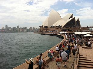
We timed our excursion perfectly. As we crossed the bridge the annual boat regatta was drawing to a climax with vessels churning up the water in all directions. As noon approached a ceremonial gun opposite the Opera House let off a booming 21-gun salute. Lunch was then followed by a ferry ride back to Milson Point to resume working for another couple of hours.

The walk across the bridge is just the start of a new regime for myself. I'm determined to lose the "Heathrow Injection" obtained while living in London. I first heard this phrase about six years ago when a returning expat noted that everyone relocating to the UK inevitably puts on 10-20 pounds. At the time I simply chuckled. However, Garry and I soon discovered it was no laughing matter. The cold weather and indoor lifestyle in London really does encourage considerable weight gain. In an attmept to reverse the damage I've now started walking to and from work; a distance of almost six kilometres daily. Garry has also put us on a low-fat, lean meat and salad diet.

On the home front things are slowly falling into place. We took procession of our apartment mid-week once our tenants had vacated. The initial inspection proved a little disappointing. While the tenants had generally kept the place in good condition it looked tired. It’s been at least ten years since the walls were last painted and its suffered inevitable wear and tear. I think we’ve found the motivation we needed to plan our long mooted renovation!

For now we’ll repaint the entire apartment and repair minor dings. Garry has already been down to the hardware store several times to purchase trestles and painting gear. Last night we settled on colour palette. We’re planning a vibrant orange/red feature wall, soft brown and cream highlights and a brilliant white ceiling. It’s a huge paint job that’s bound to keep Garry busy for the next week.

We’ve been told by our removal company that our household effects should be released from customs and quarantine some time after February 7. The ship carrying our container safely arrived in Sydney on January 23. Garry had been tracking its imminent arrival on the Internet almost daily. We’ve also purchased a new washing machine and a new TV for the bedroom. Piece by piece our lives are falling back into place.

Sunday, January 16, 2011

New posts uploaded

I plan to spend the next week or so filling in a few gaps in the current blog record of our recent travels. This includes posts on our time in Chile, including Easter Island, and several posts capturing highlights from the final days of our train journey through the Swiss Alps. 

As a start, I've posted updates today about our brief Santiago stopover and an early morning tour of the El Tatio geyser field high in the Andes. Both posts have been back-dated so that they appear online roughly around the date they occurred. You'll have to scroll down a little to find them. Check back during the week for accompanying photos I've yet to upload. Watch for more such posts in the days ahead.

Finally, for those so inclined, here's a day-by-day summary of our extraordinary sabbatical itinerary back to Australia. This little beauty has tested my HMTL coding skills to their limit. I've included all of the 11th-hour itinerary changes that occurred after we were stranded in Antarctica for three days.

DAY DATE LOCATION NOTES
SAT 11 Dec Vienna Le Meridien Hotel
SUN 12 Dec Vienna Royal Palace 
MON 13 Dec Vienna Christmas Markets
TUE 14 Dec Salzburg Mozart Dinner Concert
WED 15 Dec Kitzbuhel Picked up by Hamish
THU 16 Dec Kitzbuhel
FRI 17 Dec Liechtenstein
SAT 18 Dec Bern Glacier Express: Chur to Brig
SUN 19 Dec Interlaken Day exploring Bern
MON 20 Dec Interlaken Jungfraujoch Railway
TUE 21 Dec Santiago Evening flight from Frankfurt
WED 22 Dec Punta Arenas Transfer flight to Punta Arenas
THU 23 Dec Tour Day 1 Fly Cruise Antarctica
FRI 24 Dec Tour Day 2 Flight to South Shetlands
SAT 25 Dec Tour Day 3 Mikkelsen Harbour & Cierva Cove
SUN 26 Dec Tour Day 4 Dorian Bay & Charcot Cove
MON 27 Dec Tour Day 5 Paradise Bay & Neko Harbour
TUE 28 Dec Tour Day 6 Deception Island & Half Moon Island
WED 29 Dec Tour Day 7 Stranded in Antarctica
THU 30 Dec Tour Day 8 Stranded in Antarctica
FRI 31 Dec Tour Day 9 NYE stranded in Antarctica
SAT 1 Jan Santiago Flight to Punta Arenas
SUN 2 Jan Tour Day 1 Hotel Taha Tai. Easter Island
MON 3 Jan Tour Day 2 Rano Kau. Orongo. Ana Kakenga
TUE 4 Jan Tour Day 3 Puna Pau. Rano Raraku. Ahu Tongariki
WED 5 Jan Tour Day 4 Flight to Santiago
THU 6 Jan Tour Day 1 Morning flight to Calama
FRI 7 Jan Tour Day 2 Salar de Atacama
SAT 8 Jan Tour Day 3 Tulor & Pukara de Quitor
SUN 9 Jan Tour Day 4 El Tatio. Fly to Santiago
MON 10 Jan Santiago City Bus Tour
TUE 11 Jan Cross the Dateline
WED 12 Jan Tauranga Transfer in Auckland
THU 13 Jan Tauranga
FRI 14 Jan Auckland Evening with Matt & Shelley
SAT 15 Jan Sydney Home again!

Shipping, shopping and settling in

We’re finally back in Sydney. Initial preparations for setting up home again are already underway. We already know the container holding our household effects and Saab is scheduled to dock in Sydney on January 23. It’ll then take up to six weeks to clear quarantine and customs. 

We googled the location of the ship carrying our worldly processions last week and discovered that it was due to dock in Freemantle, West Australia on January 15; the same day we arrived back in Australia ourselves. Until our household effects clears customs we’ll been camped out in a serviced apartment literally across the road from our own property. This should make it reasonably easy to complete final preparations for moving back in. 

Garry has already taken it upon himself to repaint the entire apartment when our tenants vacate on January 25. The current paintwork is at least nine years old now so a touch up is well overdue. We also have several appliances and numerous minor items to purchase as part of our relocation. The shopping list includes a new washing machine and some outdoor furniture for our expansive main balcony. 

Of course we also have the joy of sorting out phone lines, cable television and all manner of regular household utilities. Garry plans to manage most of these chores in between job interviews. With a little luck we should be settled back in our own home by mid-February. 

At this point I’m unsure if I’ll continue maintaining the blog as its original purpose will have well and truly ended. Dear readers, what do you think?

Saturday, January 15, 2011

The final flight


Garry and I are sitting in the Qantas lounge at Auckland Airport. After exactly five weeks on the road, we're preparing to board the final flight on our leisurely journey back to Australia. In a few hours from now, we'll begin our new (or is that old ?) life in Australia. It's been five years, three months, and nine days since we departed Sydney in 2005 to embark on our grand European adventure. It's hard to believe that another chapter in our lives is drawing to a close.


We've capped off our eventful journey home with three gloriously relaxing days at my parent's beachside home. The weather has been glorious with blue skies and sunshine every day. We've also made a daily pilgrimage down to the beach to soak our feet in the surf and watch majestic waves rolling in one after the other.


We even took advantage of our jet lag early one morning rising in time to watch sunrise over the Pacific Ocean. It was a magic experience and perhaps the ideal way to draw a metaphorical line under our time in London. A new adventure is dawning. Stay tuned for more updates as we work to settle back into Australian life.


• Posted by iPhone
• Location: Puhinui Rd,Auckland Airport,New Zealand

Thursday, January 13, 2011

24 hours in Santiago


Almost six million of Chile’s 15 million people call Santiago home. As a result, the capital of Chile is a sprawling, bustling metropolitan that doesn’t look that dissimilar to any other large city. We’d originally booked ourselves into the Sheraton using loyalty points for three nights but had to abandon this plan after becoming stranded in Antarctica over New Year. As a result, we ended up spending less than 36 hours in Santiago. However, for all that we were ultimately keen to see this proved a perfectly adequate length of time.


To initially orient ourselves we bought tickets for the hop-on, hop-off bus that circles the inner city from 9.00am to 6.30pm every day. The entire circuit takes roughly two hours, giving visitors a quick sense of the city’s historical districts and its modern additions. Garry loves these bus tours as he enjoys gaining a brief sense of what it’s like to live in a given location.

After completing a circuit our first stop on the route was Santiago’s bohemian arts and cafe district, Bellavista. It was here we discovered the expansive Patio Bellavista, a delightful complex of redeveloped warehouses that now house dozens of cafes and restaurants. We stopped for a leisurely alfresco lunch before making our way toward Parque Metropolitano, expansive parkland that covers a series of hills on the city’s north side.


The 860-metre summit of the nearest hill can be reached via a funicular tramway, built in 1923. It offers an open-air ride through groves of mature trees as the sprawl of Santiago slowly unfolds before you. Santiago is huge! The hilltop itself is dominated by a 14-metre pure white statue of the Virgin Mary who stands looking serenely over the city with her arms outstretched. It is now a historic moment but still attracts regular streams of devout Catholic pilgrims.

Our next stop was the city’s historical centre located in the shadow of a small hill called Cerro Santa Lucia. Pedro de Valdivia founded the city here on February 12, 1541. Today the hill is an attractive park upon which an extensive series of terraces, paths, viewpoints, and grand stairways have been constructed. Much of this work was completed over a two-year period starting in 1872 by 150 convict labourers. The entire neo-classic construction is an impressive sight and it’s easy to imagine the city’s more fashionable citizens ostentatiously promenading here 130 years ago. The design and location do make you feel a little like royalty.


From here we wandered into the Plaza de Armas, the old city’s central square that remains the city’s heart today. The square is bordered by a series of impressive buildings that include the city’s cathedral, central post office, and City Hall. Each building was constructed during a different period creating a wonderful array of architectural styles that simply reinforce a sense of the city’s growing age. 

We wandered briefly among its ornamental palm trees, past groups playing chess at the bandstand and the inevitable flurry of illegal street vendors and buskers before making our way back to our hotel for dinner and on to the airport for our flight to New Zealand.


No doubt with a little more time we’d have visited more of Santiago’s historical buildings and perhaps a few museums. However, we appreciated spending time outdoors and saw enough to satisfy our own sense of discovery. 

Garry also enjoyed our hotel’s outdoor BBQ restaurant which always had lamb roasting on charcoal spit and every conceivable carnivore’s delight hanging on hooks nearby. If you ask him he’d tell you it was the perfect way to end our tour of Chile. Over a three-week period, we’d seen the country literally from top to bottom (from the Atacama to Punta Arenas) and east to west (from the Andean altiplano to Easter Island).

Monday, January 10, 2011

El Tatio


A tour of the Atacama Desert is incomplete without a visit to the El Tatio geyser field. Its location on the Andes altiplano, 4,320 metres above sea level, supposedly makes it the world’s highest such field. It also has a rather unique geology. Overnight sub-zero temperatures chill the plateau and its underground water source which then makes for some spectacular geothermal activity shortly after dawn.

Incredibly, an entire natural depression nestled in the mountains erupts with hundreds and hundreds of billowing steam columns and spluttering geysers. Some columns rise an impressive ten metres or more into the air while the largest geysers erupt for almost ten minutes at a time. It’s an impressive sight.


Even more remarkably, within hours the morning sun has warmed the area causing most of the geothermal activity to cease. While El Tatio’s geysers weren’t as spectacular as the geyser we saw in Iceland several years ago, the dramatic transformation from a flurry of steam columns to a barren plateau was definitely a highlight.


Given this unique dawn phenomenon, visiting the site required an exceptionally early start. El Tatio is also located almost 100 kilometres from San Pedro. As a result, we rose at 3.20am in time to join a tour group at 4am. We then endured a two-hour bus road, a third of which consisted of travel along rutted gravel roads. However, the journey was worthwhile and I’d recommend it to anyone that’s never seen geothermal activity before.

Perhaps the only negative of our entire visit was the rather meagre breakfast provided afterwards. This consisted of stale bread rolls, chocolate chip biscuits and eggs that our guide hard-boiled in a nearby hot spring. I later read that the water at El Tatio is undrinkable thanks to dangerously high arsenic levels. I certainly hope the bag in which our eggs were cooked was properly sealed!


Our journey back to San Pedro was broken up by two memorable stops. The first was a photo stop at a high-altitude wetland where we were able to watch endangered black coots nesting, flamingos wading and the odd vicuna (a type of high altitude Llama) grazing. The scene was unbelievably peaceful and idyllic. Our second stop was at the remote village of Machuca located about 4,000 metres above sea level. The village consists of a dozen adobe buildings, each capped by a quaint thatched roof of reeds. However, its most note-worthy building is a small white-washed abode church that sits on a nearby hill.


I boldly strode out to visit the church while Garry loitered in the village. He’d spotted locals cooking delicious Llama kebabs on a small charcoal BBQ. Garry probably chose the easier excursion. For those readers familiar with high-altitude travel you’ll know that air pressure falls as you rise subsequently reducing the volume of oxygen taken with each breath. As a result, climbing up to the churchyard left me breathless. I had to rest for several minutes before moving on.

Sunday, January 09, 2011

Sun-bleached history


We kicked back a notch today. As a result, the laid-back desert life lifestyle became today’s highlight. We joined a 3.5 hour tour in the morning of two local archaeological sites, Tulor and the Pukara de Quitor, then spent an afternoon by the hotel pool or dining alfresco with a local beer in hand. After a relatively full week of flights and daily excursions the change of pace was much needed.

The archaeological tour proved more interesting than expected. This is thanks in part to the captivating scenery that greeted us at each site. Our tour started at Tulor, located ten kilometres away from San Pedro de Atacama on the edge of the desert. It was here in the mid-1950s that a French archaeologist, Padre LePaige, discovered a small village of distinctive circular adobe houses.


At first, it was thought that he’d only found the wall foundations until the site was partially excavated in 1982. Researchers soon realised that shifting sands had actually buried the houses up to their roofline and thus almost every wall was completely intact. This discovery is all the more remarkable when you realise that these walls are composed of mud and straw; and are at least 1,500 years old. Today you can see just a couple of rooms partially uncovered while the remaining walls have been reburied leaving a series of curious mud rings in the ground.


Two replica houses have been constructed nearby giving you a good feel for both their design and the cool interior. These buildings also make for an impressive sight sitting stranded in thousands of acres of dry, barren desert landscape. Sadly, our visit will probably be remembered more for the unfortunate bathroom incident I suffered as we were finishing our tour of Tulor.

Buy me a few beers one day and you may hear the full story. For now I’ll simply confess that desert food got the better of me in the middle of nowhere. The embarrassing situation which resulted was then compounded when we discovered the only bathroom in the area lacked toilet paper. I’m now returning to Australia minus a pair of underwear and a large chunk of my dignity. Enough said!


Our second archaeological site, the Pukara de Quitor is a more recent settlement. It consists of a dozens of fortified structures built on steep hill overlooking a small river (more like a stream) that runs through a dramatic gorge and out into the nearby salt flats. The site was founded by the local population in the 12th Century as a defence against neighbouring villages seeking water and land in the small oasis that follows the course of the Rio San Pedro river. Today the site offers visitors a stunning view across the salt plains towards the soaring Andes mountains. The tallest peak visible is more than 6,000 metres high.


The Pukara de Quitor was also the sight of a famous battle between the Incas and the Spanish Conquisitors. In 1536 Rodrigo Ordofiez unsuccessfully tried to take the fort but was driven off. In late-1540, the Spanish returned, this time led by Francisco de Aguirre commanding 30 elite horsemen and a thousand conscripted Inca soliders. He captured the fort and as a warning to the local population then decapitated up to 200 elders and leaders, leaving their heads prominently on display.


Aside from this short tour, our only other excursion today involved a casual wander around central San Pedro looking for somewhere to dine. Our walk took us past the Church of San Pedro, built in 1744 from adobe bricks and furnished with items made from cactus wood. Yes – cactus really do have wood. We later saw several beautiful cactus wood craft pieces in the local market. If Antipodean quarantine restrictions weren’t so onerous I’m sure we’d have bought something.

Saturday, January 08, 2011

Just 35mm of rain annually


Garry and I are enjoying the desert climate at San Pedro de Atacama, located on the northern fringe of Chile's Atacama Desert. Barely 100 kilometres from our current location is the driest place on earth where it's rained four times in the last four decades (that's an average rainfall of 0.5mm annually). We've based ourselves in San Pedro where it rains 35mm annually.

The lack of rainfall became abundantly clear yesterday when we noticed a plasma television on the wall of a cafe where we ate lunch. Nothing odd about that you say? Think again. The cafe was covered by a roof of slatted branches, offering nothing more than partial shade for hungry customers. We're definitely not in lush Santiago anymore!


Our first afternoon in the Atacama saw us join an almost obligatory afternoon tour of the Valle de la Luna (Valley of the Moon) located 12km out of town. It's a fascinating landscape of weird, wind-sculptured rock formations where rain almost never falls. In fact, much of the rock in the area is actually made of little more than incredibly hard, dry rock salt crystals. Our tour ended at sunset which we watched from a narrow ridge overlooking a giant sand dune more than 100 metres high.


Our second day in the Atacama saw us take a full-day tour of the Salar de Atacama (known in English as the Atacama Salt Flats). This incredible 15,620sq km plain of dried salt lies 2,305 metres above sea level. Its surface consists of rough, jagged salt rocks that stretch as far as the eye can see. However, every so often, subterranean water rises to the surface creating spectacular brine lakes. Salt-tolerant brine shrimps thrive in these waters, attracting thousands of hungry flamingoes. We saw plenty of these birds today, all with their heads down filtering lake water through their beaks at a furious rate.


Our tour also took us up to the Andes altiplano more than 4,350 metres above sea level. Here we visited two picturesque lakes; Miscanti and Miniques. These lakes are rimmed by a thick band of bright white salt and their waters are the most iridescent blue you can imagine. Behind them sit a series of towering, arid volcanic peaks; again, more postcard fodder. We then stopped for lunch in the small rural village of Socaire noted for its adobe churches. Abode buildings are constructed of mud and straw bricks, making these rather unique buildings.


Today's tour ended with a brief stop in the village of Toconao. It's renowned for a simple, white-washed adobe bell tower built in 1750. The tower is now a protected national monument. The town owes its existence to a remarkable oasis found in a nearby valley called Quebrada de Jerez. We visited the valley earlier in the day. It's an awe-inspiring sight. Mature trees and grass nestle in the shadows while dry, desolate hills and salt plains stretch to the horizon. We learnt that each village family has a small plot in the valley where they grow fruit trees, grapes and vegetables.

Tomorrow we're off to tour the ruins of two ancient civilisations that first settled the San Pedro area. The oldest settlement discovered so far dates back to roughly 800 BC. Our final day in the Atacama will see us rise at 4am to drive 97km to El Tatio, the world's highest substantial geyser field. It sits 4,321 metres above sea level. The early rise is important as the geysers are at their most spectacular as the rising sun warms the sub-zero desert, generating impressive columns of steam. Stay tuned for more memorable photos.


PS: Keri if you're reading this post and discover spelling errors, please blame my spell-checker. When logging onto the blog the system automatically detected my location and established itself using Spanish language settings. I later tried to run the spell-checker which caused almost every word came back as an error. I know my spelling is shaky at times, but challenging every word was a rather harsh slap in the face.

Thursday, January 06, 2011

Gone but not forgotten


The itinerary of our third day on Easter Island was focused on the island's most globally recognised locations including the enigmatic Rano Raraku and the iconic Ahu Tongariki. It's fair to say that Garry loved every moment of it. The tour also featured a few additional, less well-known, highlights that were special for me. 

Regular readers of this blog will recall that I first visited Rapa Nui in November 1998. I spent 2.5 days on the island and got to see its most popular sights. However, I missed several locations including the lava tube caves at Ana Te Pahu and the long-since abandoned quarry at Puna Pau. I got to see both during this second visit.


Puna Pau supplied the crowning "topknot" or pukao stones that adorn the island's moai. Each pukao is carved from red scoria stone, a soft volcanic rock. While intuitively, these stones look like a hat for the moai, they were in fact carved to represent how the men of that time tied their long hair in a topknot bun. These days the quarry is little more than a grassy depression on a hill overlooking the Hanga Roa township. However, its original purpose is still clear as there are more than a dozen decaying pukao scattered around its rim and within the grassy bowl.


Our next stop was Ahu Akivi, an ahu platform located further inland than most of the others on the island. It was our first real taste of the majesty of Rapa Nui's moai culture. This 38-metre-long platform, restored in 1960, has seven moai statues all of a similar height, around four metres tall.  

Unusually, the statues look towards the sea. Elsewhere on the island the moai traditionally face inland. According to oral tradition, these seven figures represent seven explorers who surveyed the island for King Hotu Matua, before it was formally settled.


Our tour then headed for Rano Raraku, the volcanic hillside quarry where all of the island's moai were crafted. It's impossible to fathom how remarkable the moai culture is until you visit this site. The volcano's eastern rim was home to a bustling quarry where more than one thousand giant statues were carved and  transported up to 18kms across the island, all without the aid of modern tools and transportation.


When I first visited in 1999, tourists were free to wander among its remains without restriction. I recall we even climbed onto one of the incomplete, partially carved statues lying in the quarry. I'm pleased to say that sealed paths have now been introduced and tourists are forbidden to venture from them at any time. However, you can still wander freely along the shore of the reed-lined lake that fills the volcano's crater.

Rano Raraku is a fascinating place. Towards the top of the quarry site, you encounter large, empty spaces in the rock wall. These are the remaining shells from which moai have been carved, extracted, and moved away. Surprisingly, not all of the statues have been carried away. There are two unfinished statues visible within the quarry site, each still attached to the mountain.


The guided path then takes you on to Te Tokonga, the largest statue ever built. This monster made by an optimistic group of carvers has a height of 21.75 meters and an estimated weight of 200 tons. It was never finished. When it was abandoned, the carvers were still working on carving trenches along its sides to detach it from the surrounding rock face. It's unclear whether this statue was abandoned because the Moai era ended, or because the workers simply thought it would be too hard to transport.


However, Rano Raraku's most iconic sight is its "forest" of partially buried moai. These giant heads protrude from the ground awaiting transportation that ultimately never came. The islanders originally buried them as part of their non-mechanical erection process.

Once detached from the volcano's elevated rock face, each statue was slid down the hill onto the soil-filled lower slopes of Rano Raraku. Here, a great pit was dug. As the statue reached its designated pit, gravity was used to tilt it until it was fully erected. The moai was then transported in a vertical position across the island to its final resting place.


Our final stop before lunch was Ahu Tongariki. Without a doubt, this sight is one of the most enduring and instantly recognisable images of Easter Island. Ahu Tongariki is the biggest stone ahu on the island. It consists of 15 moai statues including the island's tallest and heaviest moai. Ahu Tongariki is located on the east side of Rapa Nui, about 1km away from Rano Raraku.

This impressive ahu was restored in the 1990s, funded by a $2 million donation from the Government of Japan and the donation of a crane by Tadano, a Japanese crane company. Its tallest moai, measuring 9 metres, is also the heaviest statue successfully transported and placed on an ahu anywhere on the island. Its weight of 86 tons was verified by the crane used in the platform's restoration.


The remainder of our day was spent visiting what I'd consider some of Rapa Nui's more kitsch sights. This included the navel of the world, Anakena Beach, and Ahu Nau-Nau. The navel, or Te Pito o te Henua, sits just above the high tide mark on the island's west coast. It consists of a large stone sphere, framed by four smaller spheres and encircled by a low rock wall. 

Archeologists believe it is a symbolic navel, denoting the island's location in the middle of the Pacific Ocean. I must admit that despite seeing it twice, I still struggle to believe these seamless spheres really are an ancient structure rather than some more recently installed kitsch tourist attraction.


Anakena is the island's only real sand beach. Tour guides always take you here. Someone, somewhere, at some point in time, has clearly convinced the local tour operators that all tourists want to swim. I suspect it's a tradition encouraged by backpackers over the years. However, aside from a small plantation of shady palm trees, the beach does have two other redeeming attributes - a pair of ahu platforms.  


The first of these is Ahu Nau-Nau which has seven restored moai statues, two of which are broken. The platform sits just above the sand line making for an interesting juxtaposition with the beach's modern palm plantation, picnic tables, and body-surfing tourists.

The second platform, called Ahu Ature Huke, contains one forlorn moai. This lonely figure is the first moai statue ever to be restored and raised. Its restoration was undertaken by Norwegian explorer Thor Heyerdahl in 1956. He successfully raised the moai using only rocks, logs, and rope. The logs were used as levers to lift the statue and rocks were put underneath, raising the statue little by little.


Unfortunately, I didn't take a photo of Ahu Ature Huke. However, I did capture an image of Ahu Te Pito Kura while on our way to Anakena. This is the resting place for the island's largest successfully transported moai configuration, i.e. it's the largest if you include its pukao topknot stone in the final calculation. The pukao alone reputably weighs 12 tons and is the largest of its kind successfully relocated and erected anywhere on Rapa Nui.


The following morning we caught a flight back to the mainland arriving shortly before 7:00pm. I booked us into the nearby Sheraton using loyalty points, ready for another early morning departure at 7:15am to Calama and the next sector of our Chilean adventure.