Showing posts with label Utah. Show all posts

Saturday, April 06, 2024

The Grand Canyon


Over the years I’ve been fortunate enough to visit the Grand Canyon twice. Both visits were day tours from Las Vegas. I’ve also passed over it at 30,000 feet while flying trans-continental across the USA. My first overflight took place while travelling to Syracuse, New York, as an exchange student in 1983. No matter what your vantage point, the Grand Canyon never fails to impress. 

My first ground visit occurred in July 2000. At the time, I was on my way to Text 100's San Francisco office for a two-week General Manager’s secondment. I flew into LA on Friday 28 July, passed through immigration and transferred mid-morning onto a flight to Las Vegas. 


I spent three days exploring Sin City, including a spectacular helicopter flight that took me into the Grand Canyon at Grand Canyon West. The day trip involved two separate activities. The first was a breathtaking flight from Henderson Airport over the Hoover Dam, Lake Mead and the Grand Canyon, concluding with a landing 3,200 feet below the rim. 

We landed on a sloping plateau, about 30 metres above the canyon floor, with an uninterrupted view of the Colorado River below. Our group of four, excluding the pilot, spent about 20 minutes on the ground toasting our visit with a glass of bubbles. 


I’ll never forget the moment we flew over the canyon rim. The sensation of the ground suddenly falling away into a vast abyss will stay with me for the rest of my life. An American couple flying with me made the moment all the more memorable. As we passed the rim, the wife let out a classic melodramatic “wow” followed by more gasps and groans in a distinctly American drawl. Her breathless enthusiasm was rather infectious. 

The tour included a video of our flight. When you play it back, this woman's delirious commentary can be heard in the background. Decades later it still makes me chuckle. I've arranged for the VHS tape to be converted to MPEG4.  I'll try to upload a reel soon.  

Perhaps the most astonishing aspect of this video was its creation. The pilot controlled two cameras as we flew, skilfully cutting from one to the other as the scenery unfolded below. Then, when our tour was done, he opened a hatch at the helicopter’s rear revealing a bank of video recorders. The company had set these up to simultaneously record our flight. The pilot ejected a tape from each machine and gave a copy to each of us. It's hard not to be impressed by such an efficient set-up.


From the canyon floor, we flew to Guano Point on the West Rim. Here members of the local Hualapai Indian tribe took us on a walk to view the canyon from ground level. Along the way, our local guide shared stories of the tribe’s history in the area and explained the magnificent geography unfolding before us. Of course, a ubiquitous display of handcrafts was also on offer. 

In the years since the Hualapai have expanded their simple tourism venture to include an impressive glass floor Skywalk platform. This lets you walk out past the rim and experience the same “ground falling away” sensation I enjoyed on my helicopter flight.


My second visit to the Grand Canyon, in 2002, was also by air. However, this time I was en route to Utah’s iconic Monument Valley courtesy of the aptly named Grand Canyon Scenic Airlines. My day trip started with a flight to Grand Canyon National Park Airport in a relatively spacious De Havilland Twin Otter Vistaliner. From here we were taken by minivan to the Grand Canyon South Rim to soak in a classic view of the canyon itself.

Most of the tourism images you see of the Grand Canyon are taken from the south rim. The canyon is 731 meters deep at this point and spans more than 10km to the northern rim. I can confidently confirm that the vista is every bit as awe-inspiring as those postcards and posters promise. Although, like a typical antipodean traveller, I was equally enamoured by the squirrels running rampant around the lookout’s stunning vantage points.


We then returned to the airport and took a second flight to Goulding's-Monument Valley-Oljato Regional Airport. Landing here marked my first visit to Utah as much of Monument Valley’s famous landscape straddles the Arizona state border.  This remote little airport can be seen in the image above.

Monument Valley isn't a valley in the conventional sense, but rather, a flat and desolate landscape surrounded by crumbling rock formations that rise hundreds of metres into the air. They're the last remnants of a sandstone layer that once covered the region, eroded by hot dry winds that howl through the desert.


Once again, the local tribespeople were our guides. Our Navajo hosts took us on a four-wheel drive through the desert, stopping to take in many of the national park’s iconic views. The area’s dramatic rustic red buttes and mesa have long been used as a classic background for Hollywood Westerns, a tradition that began with Stagecoach, starring John Wayne, in 1939. 

It also provided the backdrop for one of Forrest Gump’s more memorable scenes. Do you recall the scene where Forrest Gump runs across the country? After gaining a large group of followers he decides it is time to stop. This pivotal moment in the movie was shot on Highway 163 in Monument Valley. The Forest Gump viewpoint has become so renowned that Google Maps now marks its location a few kilometres north of the state border.


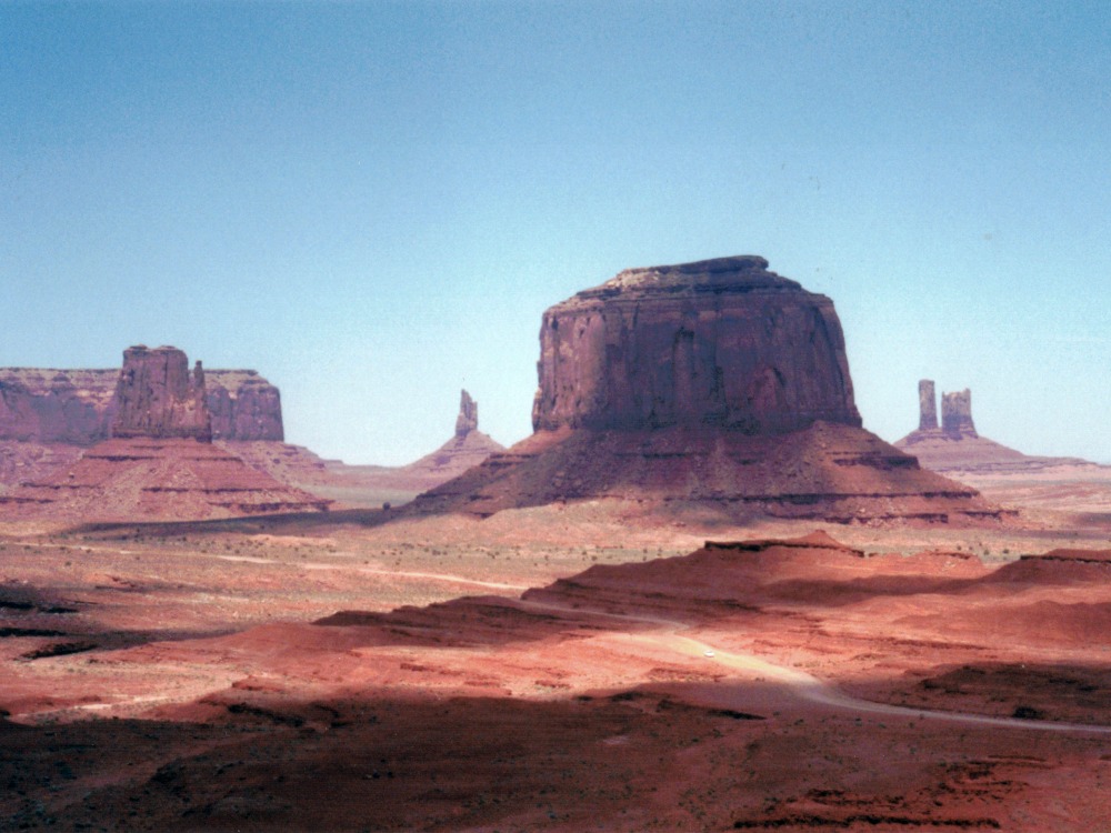
However, my day tour focused on classic vistas south of the border including North Window Overlook and John Ford Point.  The latter location is ironically named after a Hollywood producer. Here you get a stunning view of the Three Sisters, a tripartite collection of soaring rock pillars.

The image of me in a cowboy hat above was taken at a stunning lookout in the Monument Valley Tribal Park Visitor Center. It shows West Mitten Butte and East Mitten Butte, just two of at least a dozen similar formations visible from this elevated location. Just out of view to the right is the equally impressive Merrick Butte. It's best viewed from a lookout called Artist’s Point, as shown in the third image above.


At John Ford Point, a Navajo local kindly rode his horse onto an outcrop overlooking the valley below. As you see above, this allowed us tourists to capture an iconic Lone Ranger moment. Then, for a healthy tip, he let us sit on his horse for another memorable photo opportunity. Naturally, I was inspired to capture my own cliche moment for immortality.  


However, the breathtaking views of the two Mittens ultimately captivated me. These photogenic buttes, each with an opposing rock finger, are the iconic formations most often associated with Monument Valley. Driving past these towering burnt ochre outcrops was awe-inspiring and worth every penny of my pricy day trip.


The tour finished with a return flight to Grand Canyon National Park Airport where I transferred onto a tiny Cessna Caravan. This aircraft normally seats nine passengers. However, for reasons unbeknown to me, the pilot flew a weight-restricted flight back to Las Vegas. As a result, there were only four of us on board. I was even weighed before take-off.

I vividly recall buying a souvenir shirt and some sort of knick-knack at the airport, then witnessing an airline staff member's crestfallen face as I returned to the gate with my goodies. Thanks to my shopping spree this staff member was unceremoniously offloaded from the flight.

Then, as we prepared to take off, the pilot kindly warned us that the afternoon flights are often rather bumpy. As he explained, the sun’s unrelenting heat generates increasingly turbulent updrafts as the day progresses. He wasn’t wrong. More than once our tiny aircraft was bounced around in clear air as we passed over the Colorado River’s ancient rifts and gullies.


NOTE: April 2024
The images illustrating this story were scanned from original printed photos. As you can see, I have plenty of spectacular Kodak moments waiting to enter the digital era.

Sunday, September 14, 2014

Salt Lake City

The Upper Colorado River Scenic Byway (Highway 128) is a spectacular drive along the Colorado River gorge, a few miles north of Moab, Utah. The route begins on a high plateau where the river meanders through flat, dry grassland. The road then follows the river as it begins to carve dramatic a gash into the landscape. This modest gully is the beginning of a canyon that ultimately form the Grand Canyon hundreds miles downstream.

Garry and I drove the highway on our way back to Salt Lake City. I’d driven it three years earlier and was thrilled to be able to share it with Garry. The road winds its way through spectacular gorges and broad river valleys for almost 28 miles.  As the river carves its way west, the resulting gorge becomes increasingly dramatic. Towering red sandstone cliffs line much of the route.  As you turn each corner, the cliffs appear to rise ever higher and steeper. It’s a truly breathtaking scene. 

We took a brief detour toards the ghost town of Cisco before rejoining the interstate highway. Cisco was founded as a water refilling station for steam locomotives in 19th Century. However, the demise of steam engines also sealed the town's fate and it was eventually abandoned. Today, all you can see are derelict wooden houses and rusting cars standing forlornly on an empty, barren plain. It's rather surreal.

Two hours later we enjoyed a late lunch at picnic ground on the banks of the Spanish Fork River.  We were amused by the Bear Country signs strung up around the picnic ground.  That is, until we took a short walk across a footbridge and found fresh bear tracks in the soft mud.  It was a rather sobering moment!

We arrived back in Salt Lake City mid-afternoon. This gave us just enough time to take a walking tour of downtown. Garry wasn’t impressed. He’s never been a fan of religious venues. Temple Square, the heartland of the Mormon Church, proved no different. As for me, I was curious to witness American’s only home-grown religion up close.

Temple Square is dominated by a series of church buildings, some relatively modern and others more than century old.  This includes the spectacular Salt Lake Temple. Clad in white stone, it was painstakingly built by Mormon pioneers between 1853 and 1893. Unfortunately it’s not open to the public.

Temple Square is filled with statues immortalizing the struggle of Utah's early pioneers and core tenants of the Mormon faith. The surrounding grounds are beautifully maintained. The traditionally, stark and grey-concrete landscape of a typical American city has been transformed by manicured lawns, dazzling flower beds, mature trees and verdant shrubs. It was all very immaculate.

From Temple Square we made our way up to Capitol Hill to see the State Capitol building. It’s impressive structure, capped by a domed rotunda.  Despite our desert surrounding, the building sits in the middle of an impossibly green lawn. Garry and I were equally fascinated by the surrounding residential district. The homes are rather modest.  They're nothing like the turn-of-the-century mansions we’d expected to find.

I had hoped to catch a rehearsal of the famous Mormon Tabernacle Choir. Unfortunately the scheduled session had been retimed for special 9/11 recording.  As a result, we arrived at the published session time just as the building was closing for the evening. I suspect Garry was secretly relieved.

No doubt Garry will tell you that the highlight of our Salt Lake City visit was dinner. While returning to our hotel we stumbled across a rather fancy looking Brazilian Churrascaria . These restaurants serve meat on enormous metal rods which waiters continually carve on to your plate as they wander by. We first encountered this dining experience in Rio.  In the years since, we've enjoyed similar venues in London and New York.

Salt Lake City proved no different. We samples an array of meat, accompanied by a superb Napa Valley wine. Even the salad bar was an experience.  It offered dozens of truly sumptuous dishes, including a particularly delicious smoked salmon fillet. Needless to say we returned to our hotel with our appetite fully sated.


Thursday, September 11, 2014

Arches National Park


Some images from our adventures today. More details tomorrow.  

However, if you want to get a feel for our excursions through Arches National Park feel free to read a blog post I published when I first visited this scenic park in July 2012.  It was this weekend adventure that prompted me to suggest our last-minute change of itinerary. I'm delighted to report that Garry was just as mesmerised by the scenery today as I was three years ago.


Now why didn't Garry want me standing on this rocky outcrop for a classic photo memory?  And just to be clear, that's not me posing for a photo.  I did try and convince Garry it would be awesome but he wasn't persuaded.


As you can see the landscape at Canyonlands National Park lives up to its billing. The photos above were taken from Dead Horse Point. Iconic scenes from the movie, Thelma & Louise, starring Susan Sarandon and Geena Davis, were filmed less than a kilometre from this viewpoint.


For me, the view shown above is one of the park's more iconic landscapes. It's called Park Avenue.  It's also one of the first sights you encounter as you enter the park.  The view itself is accessed via a 400-metre trail from a car park along Arches Scenic Drive.  

I can't tell you how many times I've had people ask if this was taken in Utah. It really does look like the Wild West we've grown up with in Hollywood movies. One day I'll publish a post about my day trip to Monument Valley where many of John Wayne's iconic backdrops were actually filmed. 

UPDATE: I’ve finally published a retrospective post about Monument Valley.


The photos above were taken along the Windows Trail.  The bottom photo shows the North Window Arch It's one of the larger national arch formations in the park and is one of three arches along the trail.

This is a well-maintained walking track that traces a 2km loop from the main car park, up a series of rocky slopes, and on towards North Window Arch.  The trail then leads on to the South Window Arch and finally the Turret Arch. All three arches can see from the park's main road several miles away.


Wednesday, September 10, 2014

1100 kms later...

"Tuesday's forecast is for a high of 1°C and an overnight low of -5°C. Expect constant rain turning to snow for the next 48 hours. Snow will accumulate up to 4cm in places."

This was the forecast that greeted us yesterday morning as we made final preparations to spend three days and two nights touring Glacier National Park. Our itinerary included a night in a cabin on the shores of Lower Saint Mary Lake, and a second night on the edge of the park. In other words, our itinerary focused on enjoying the great outdoors.

Furthermore, after repositioning to a motel in Polson, on the outskirts of the park, we then planned to spend the next day on the park's famous “Going to the Sun Road” to reach Lower Saint Mary Lake. This 50-mile mountain road is considered one of the USA's most iconic scenic routes. Popular tour guides describe the road as an asphalt ribbon that hugs the mountainside. At times it winds through tight curves, and passengers on the passenger side of the vehicle can look over the road’s edge, while slowly rising to 6,646 feet over the remote Logan Pass.  This didn't sound like the kind of place to be trapped in a snowstorm.

As a result, Garry and I made a last-minute decision to change our itinerary and head south rather than north. Earlier in the year it had proven impossible to book accommodation around the park without paying one night’s deposit. This meant that the money for our cabins had effectively been spent already.  We were therefore keen to keep any change as cheap as possible.  An hour of internet searching and phone calls resulted in plans for a new “cost-effective” itinerary.

So where are we now?  Tonight (Tuesday) Garry and I are settled comfortably in at Moab. It’s a small town in central Utah, about 200 miles southeast of Salt Lake City. Moab sits by the banks of the Colorado River. It’s here that the river begins to carve out canyons that eventually morph into the Grand Canyon several hundred miles west. It’s also the only place where you can actual drive along the canyon floor as the river winds its way towards the Pacific Ocean.

To get here we drove a total of 732 miles, or 1,178kms over two days.  Yesterday we drove more than seven hours from Bozeman, Montana to Salt Lake City, then another 3.5 hours today. Our route yesterday took us through Idaho for the first time. We can report that the state is a rather sparsely populated expanse of mountains, valleys and vast brown-grass smothered ranches. There's not much to see here. Although we did learn that Idaho sits halfway between the North Pole and the Equator.
 
In fact, yesterday’s highlight was a quick stop at the Berkeley Pit in Butte (the town's name is pronounced “Beauty” - which you find rather ironic in a moment). The pit was once the largest open cast mine the USA. More than 1.4 billion tonnes of ore was extracted from its depths over a period of 28 years.  When the mine finally closed the pit was more than 1,800 feet.

Today, it’s little more than giant, barren lake on the edge of town. However, you cannot swim on boat on the “lake” as its water is saturated with heavy metals that have leached from the surrounding rock. It’s now considered one of the USA’s most toxic sites in need of decontamination.

Currently the lake's surface is below ground water level so it acts as a 'sink", drawing water towards it.  However, were the lake to rise any further the opposite process would occur and its deadly chemical soap would seep into the surrounding ground water.  As a result, pumps work around the clock to extract water from the pit.

Today we stopped for a late lunch in Arches National Park, four miles north of Moab. You can see some of the photos we took above before the weather closed in.  Fortunately, tomorrow's forecast is for stunning weather  so we’ll come back for a more leisurely tour. Stay tuned for some wonderfully sunlit images.

Update: 7:00pm
We’ve just heard that the Going to the Sun road was closed to traffic earlier today. Yesterday's change of plans was clearly the right decision.

Update: 13 September
The Going to the Sun road has finally reopened along its full length after closing for five days.