Thursday, September 04, 2014

The wild kingdom

More than anything else Garry wanted to see plenty of wildfire at Yellowstone. He wasn’t disappointed. We drove into the national park shortly after lunch today. Within half an hour we’d seen a fox and pair of deer cross the road, followed by the most extraordinary bison sighting in the Lamar Valley.

Initially we saw herds of bison, also known as buffalo (that’s right, they’re one and the same creature), grazing in the distance. They were tiny brown blobs at best. However, as we crested a small rise we suddenly came upon lone bison less than ten metres from the road’s edge. We parked the car and stood in awe as this majestic beast wandered by. We then returned to our car and slowly followed it along the road for another 50 metres before it finally veered away. Awesome!

The stunning scenery became our next Yellowstone experience. Our first awe inspiring moment came when we stopped at the Calcite Springs Overlook. For some bizarre reason it’s not even marked on official park maps. The vertigo inducing outlook offers a breath-taking view of the Yellowstone River winding its way through the Grand Canyon of Yellowstone. If this view isn’t worth noting, then we’re in for some spectacular scenic moments.

Our next stop was Tower Falls, one of the park’s most iconic locations. The falls get their name from volcanic breccias pinnacles that line the ridge from which Tower Creek cascades. They’re the oddest formations you’ll ever see. It was a beautiful scene but not quite the postcard moment we’d expected. We’re hoping that tomorrow’s tour of the Upper and Lower Falls, another iconic landmark, will do a better job of meeting expectations.

These falls are just a mile from Canyon Lodge, our base for the next two nights. The lodge sits right in the heart of Yellowstone. From here we’re planning to do more wildfire spotting in the nearby Hayden Valley and soak in dramatic views of the Grand Canyon of Yellowstone. The complex here also includes an excellent visitor’s centre filled with displays on the region’s geology, history, flora and fauna. I loved its room-sized relief model of the entire park.

America's most beautiful roadway

Wow! It’s the first word that comes to mind when describing the Beartooth Highway. This stunning route into the northeast corner of Yellowstone National Park has been called “the most beautiful roadway in America.” Garry and I think the accolade is well deserved. I must admit I was rather skeptical before we set out from the town of Red Lodge. We’ve driven many scenic routes in our time, descriptions of which were sometimes a little prone to hype.

However, the Beartooth Highway didn’t disappoint. The road begins by entering the impressive Rock Creek Canyon. Imagine if you can, a broad canyon, framed by granite peaks with a floor shaped into a graceful arc by long vanished glaciers. The road then steadily ascends through seven miles of breath-taking switchbacks, offering ever more stunning views of the valley below. At 9,190 feet the road reaches an outcrop aptly named Vista Point.

 Garry and I stopped here to soak in the view and watch friendly chipmunks beg for food. From here we rose up onto Hellroaring Plateau, an awesome wind-swept expanse of alpine tundra. The route was dotted with snow drifts, ragged canyons and meltwater lakes. Our drive was also blessed with blue skies and sunshine the entire way.

The road continued climbing until we reached a staggering 10,947 feet above sea level. Soon after cresting Beartooth Pass we found ourselves winding through more picture perfect meltwater lakes. One lake in particular was magic. I begged Garry to stop long enough for us to pause and soak in the view. We later learnt that the road is closed for seven months every year as snow drifts up to 20 metres deep make it impassable.

The largest lake in the area is Beartooth Lake. This alpine lake sits at 8,901 feet, its waters reflecting Beartooth Butte, a towering red-banded sandstone mesa. Incredibly, at 10,541 feet, the Butte’s summit lies below that of Beartooth Pass. The route then took us past two eroded volcanic peaks before finally reaching the entrance to Yellowstone.

Wednesday, September 03, 2014

Custer's last stand

Today was the first of two “repositioning” days we’ve scheduled on our road trip. These are days devoted to relocating between the three major regions we’re visiting; the Black Hills of South Dakota, Yellowstone National Park and Glacier National Park. Each involves driving up to 450kms in a single day. Today we drove from Buffalo, Wyoming to Red Lodge, Montana; a journey of 350kms.

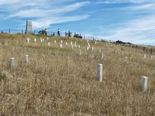
Our route took us past Little Bighorn Battlefield National Monument. This wind-swept expanse of grassy knolls and gentle ravines was the site of General Custer’s last stand. It was here in the Summer of 1876 that more than 260 soldiers and attached personnel of the US 7th Calvary were defeated in battle by several thousand North American Indians.

The battle of Little Bighorn was the last great victory of the Northern Plains Indians fighting to preserve their ancestral, nomadic way of life. Its origins trace back to the persistent violation of “native title” treaties signed between the Indians and European settlers in the mid-1880s. At the time large tracts of the Dakotas, Wyoming and Montana were set aside as Indian territory. The Government promised to protect the native population from “all depredations by people of the United States.”

However, the discovery of gold in the Black Hills of South Dakota in 1868, and shortly after in valleys north of Yellowstone, saw thousands of men, women and children descend upon the region within months. The migrants cared little for the Indian way of life. They had little or no regard for the sanctity of native hunting grounds; indiscriminatingly slaughtering buffalo and desecrating ceremonial sites.

Initially the US Army attempted to keep the arriving masses away. It then tried to buy the Black Hills. The Lakota Indians refused to sell one of their most sacred locations. The local tribes began raiding settlements and attacking travelers on wagon trails passing through their land. In December 1875, the Government ordered the tribes to return to reservations it had established by treaty. Those who refused were declared “hostile.” This declaration set the scene for the battle that subsequently unfolded.

General Custer met his untimely death on a small grassy knoll on June 25 1876. The place where he and his men fell has been immortalized by white marble markers. More than 265 of these marble headstones are scattered across the area, including several dozen concentrated on Last Stand Hill. In typical colonial fashion, the hill’s crest is dominated by a large marble cairn. Custer was originally buried here. However his remains were subsequently exhumed and reburied at the West Point military academy a decade later.

On the hill’s western slope a graceful Indian Memorial commemorates the tribes that fought and those that died. The circular memorial was completed in 2013. It’s dominated by an arresting wireframe sculpture of warriors galloping into battle. An arc of marble walls encloses the memorial, each telling the story of an Indian tribe involved in the battle. Nearby, a handful of red granite markers note places where Indian warriors fell in death. The Park Service began erecting these markers in 1999, more than 120 years after the “European” marble headstones.

Garry and I spent more than hour wandering the battlefield; visiting Last Stand Hill, touring the local interpretative centre and watching an excellent documentary film about the battle and its origins. The entire set up is incredibly well done and made for a refreshing break on our journey toward Yellowstone.

Tomorrow we’ll travel into the National Park itself via the rugged Beartooth Highway. They say this road is one of the most scenic routes in all of North America. Watch this space!

Tuesday, September 02, 2014

Devil's Tower


Garry and I have spent the day slowly making our way West towards Yellowstone National Park. Today's touring highlights include a brief stop at the Air & Space Museum attached to Ellsworth Air Force Base, a wander along the lovingly restored Main Street of Deadwood and a hike around the base of Devil's Tower.

Devil's Tower is possibly best known for its starring role as the back drop for Steven Spielberg's movie classic, Close Encounters of the Third Kind. I recall watching the movie as a child and being absolutely fascinated by its soaring features.  It really did look like something from outer space.

The tower is the eroded remains of a volcanic intrusion, created deep underground and slowly revealed over eons by the elements.  It rises more than 263 metres above the surrounding landscape.  Its sides are corrugated by long columns of solid green-grey igneous rock. It first comes into view more than 20 miles away. Its form immediately recognizable and simply grows in statue as the pass miles pass.

Garry and I stopped for a picnic at its base before taking a leisurely 40 minute stroll around its circumference. We spotted a pair of climbers about halfway into our journey. They come from all over to try their hand at scaling its angled rock face.  We never grew tired of watching its profile morph as we walked in its shadow.

However, the highlight of the day for me had to be the Black-tailed Prairie Dogs.  A sprawling "town" of these delightful, squeaking animals is located along the tower's access road.  We stopped to watch dozens and dozens of these furry little socialites go about their business. A few family packs complete with babies even made a brief appearance.  Too cute!

Our route to the Devil's Tower took us past Deadwood, one of Hollywood's original wild west towns.  It was once the home of Wild Bill Hickok and Calamity Jane.  Both infamous locals are buried in the town's charming cemetery.  The town itself has been carefully restored over the last two decades, its preservation funded by taxes dollars from gambling venues scattered throughout the town.

Our first stop of the day was the South Dakota Air & Space Museum.  Its primary theme is focused on the Cold War as the neighbouring air force base is home to a squadron of advanced high-speed B-1B Lancer nuclear-capable bombers, one of only two squadrons in the USA.  These formidable planes can carry deadly nuclear weapons swiftly across the Atlantic in a matter of hours. A retired model sits pride of place at the museum's entrance.

The base was also home to separate squadrons of Minutemen II intercontinental ballistic missiles. For more than three decades, a field of 150 Minuteman II missiles and 15 launch-control centers covered more than 13,500 square miles (34,964.8 km2) of southwestern South Dakota.  The last of these missiles were deactivated in 1994 under the terms of the START treaty signed with the Soviet Union in 1991.  Two inactive missiles remain on display in their original silos.

The supersonic Hound Dog nuclear cruise missiles are also impressive. The B-1B Lancer carried two of these sleek white jet-propelled weapons under its wings. They totally look the part, aerodynamically stretching almost five metres from tip to tail (below - with Garry providing scale). It seemed extravagant to have such a large plane only fitted to carry two missiles. That is until you realize that each of these 790 kg missiles unleashes a blast three times larger than that which flatten Hiroshima.  You're inevitably left wondering how such a small device can wreak such havoc.

Monday, September 01, 2014

Granite immortality

Garry has finally seen Mount Rushmore. It was wonderful to be able to share with him a special moment I'd enjoyed more than six years ago. However, we weren't alone. The memorial site was packed this morning with visitors and their endless summer convoy of RV camper vans.

After spending a couple of hour viewing the granite presidents from every angle, we escaped the RV onslaught by taking a scenic detour along Iron Mountain road. This is a narrow, winding road that makes its way up the face of neighbouring mountains. Its route was carefully surveyed in the 1930s to provide travelers with stunning (albeit distant) views of Mount Rushmore.
 
The road is an impressive piece of engineering. The route include three unnervingly narrow tunnels blasted through solid granite and two "pigtail" bridges which lap around and over the road you've just traversed. However, nothing is left to chance.  For example, each tunnel is carved on an alignment that ensures Mount Rushmore is always framed perfectly as you exit its confines.

We then turned onto the Needles Highway which gradually winds its way towards a series of towering granite pinnacles before finally passing through another series of equally stunning tunnels.  One of these tunnel exits into a dramatic natural amphitheater surrounded by a ring of soaring granite fingers. It's truly breath-taking.

More photos and statistics to come shortly.

Posted from my iPhone.

In the (time) zone

Garry and I finally landed in Rapid City, South Dakota. It's taken four flights, across eight time zones to get here. Our "day" began with a 7:05am flight to Brisbane where we caught our trans-Pacific leg to Los Angeles. From here we flew to Denver, stopping for a few hours to enjoy lunch at the airport, before finally catching our transfer to Rapid City.

It's been a long and weary day. However, Garry and I have devised a clever way to combat jet lag. Over the years we've developed quite a tradition with our USA road trips. We start our journey with a trip to the local Walmart Superstore to stock up on picnic supplies. These stores are a cross between an enormous supermarket and a variety discount store; all conveniently rolled into one giant building.

This evening we spent almost two hours buying a dirt cheap esky and filling it with cold drinks, sliced meats, salad, and fruit. We also grabbed a cheap picnic set, a travel rug, and a few other knick-knacks at ridiculously low prices. Several years ago we worked out that for the price of a couple of decent meals, we could stock up with everything we'd need for a fortnight of picnic adventures.

Tomorrow we're off to explore the Black Hills of Dakota, including the famous presidential facade of Mount Rushmore. Temperatures are predicted to be in the mid-20s with a late afternoon thunderstorm. It should be perfect weather for a day out enjoying the great outdoors.  Hertz has also come to the party. We've been upgraded to an enormous, leather-clad SUV which should make light work of the 1500kms ahead

Stay tuned for more updates in the days ahead.

Posted from my iPhone.
Rapid City, South Dakota, USA

UPDATE:  
You follow our travel adventures in South Dakota, Wyoming, and Yellowstone starting with this post. Click through our journey as it unfolded by selecting the New Post link at the bottom of each post.