Wednesday, December 29, 2010

Life on a volcano


Having successfully stepped onto the shore of Antarctica our cruise made its way back across the swelling waters of the Bransfield Strait. Once again most of us retired early for the night as the rolling boat played havoc with our senses. However, just prior to entering the main strait the captain made a brief detour through a narrow scenic passage called the Friera Channel. It was here that we enjoyed the most memorable sunset of our entire cruise.

The following morning we woke early to witness our ship entering the narrow entrance of Foster Bay at Deception Island. The bay is actually the sunken caldera of an active volcano. Deception Island last erupted in 1963, destroying part of a British research base at Whalers Bay. The base was evacuated and has remained abandoned ever since. Our ship dropped anchor in the bay shortly before 8am after carefully making its way through the caldera's treacherous fog-shrouded entrance.


After breakfast we boarded the zodiacs and made our way ashore. We then spent several hours exploring the rusting remains of a Norwegian whaling station and the British research base. The island once boasted an active airfield. Today all the remains of this facility is a large, decaying aircraft hanger which also marks the boundary of a nature reserve closed to visitors.

We reversed our path and made our way back along the shore past abandoned wooden boats and sun-bleached whale boats towards a low ridge on the edge of the island. On a clear day this ridge, called Neptune’s Window, affords a glimpse of the Antarctic peninsula. Historians believe that the first conclusive sighting of the mainland was made by explorers from this vantage point.

Mid-morning we set sail again for Half Moon Island, a small crescent of rock located off the coast of the South Shetland Islands. We ventured ashore again to watch Chinstrap penguins nesting among the rocks. Once again we were lucky enough to watch the birds feeding their young or incubating their precious clutch of eggs – usually no more than two eggs. It was here we also saw our first, and only, Maraconi penguin on the entire cruise. These birds can be identified by a series of prominent yellow feathers on either side of their head.

We then set sail for Maxwell Bay on King George island thus marking the end of our cruise itinerary – or so we thought. As I’ve posted earlier, low cloud and fog prevented our return flight from landing for another three days and so our Antarctic adventure continued on into the New Year.

Tuesday, December 28, 2010

The final continent


Our fourth day in Antarctica proved to be the highlight of our entire cruise. It was also our busiest day on tour with three separate excursions. We later learnt that our cruise enjoyed more excursions that any other so far this season. The weather played a significant role in us realising such a packed agenda. As had happened on Boxing Day, we woke to more sunshine and blue sky on December 27.

I was particularly excited to see such perfect weather as this was to be the day that Garry and I finally stepped foot on the Antarctic mainland. Up to this point we’d only ventured onto numerous islands off the coast of the Antarctic Peninsula. While geographers consider these islands part of the Antarctic territory, I wanted to step foot on the continent itself and thus truly claimed to have visited every continent on Earth.

Our first expedition of the day though saw us take to the boat and explore the ice flow filled waters of Paradise Bay. This bay is aptly named. As with so many locations on the Antarctic peninsula the area is flanked by stunning mountain peaks (clad in snow and ice of course). The head of the bay is also fringed by several spectacular glaciers, each of which sheds fresh bergs on a daily basis.

The eastern corner of the bay is also highly sheltered resulting in a zone of perfectly still water. Imagine this scene if you can; gliding silently through iridescent blue bergs as a vista of stunning mountains are reflected as perfect mirror images in the water surrounding your boat. This was truly the stuff that Antarctic postcards are made of. Words simply cannot do justice to the experience.

Our second stop of the day was equally mind-blowing. We cruised to the opposite end of Paradise Bay, to a rocky outcrop called Waterboat Point. At low tide it’s joined to the mainland by a natural causeway. However, when we landed the tide was in and so we couldn’t really claim to have stood on the Antarctic peninsula. This sheltered, picturesque location is noted in history as the site where two young men (the oldest of whom was 23) lived an entire winter alone in 1822.

In more recent years Chile has built a research base at Waterboat Point, right the middle of an active Gentoo penguin colony. As a result, visitors reach the base’s building by literally walking around the nests of penguins incubating their precious clutch of eggs. Garry and I was left speechless by the experience. As we quietly walked along a guano smeared path we witnessed one penguin after another adjusting its eggs, while other fended off scavenging birds. We even saw a couple of penguins mating, a rare sight so late in the season.

While at the base we stopped to get an Antarctic base stamp in our passports. This was to become the first of three such stamps we secured during our cruise. The base also had a small museum and gift shop in operation. We indulged ourselves and purchased a couple of long-sleeve t-shirts as mementos of our visit.

Our third and final excursion of the day was the iconic moment we’d been waiting for! Our ship sailed on into Neko Harbour, yet another picturesque bay, located on the peninsula. It was here that Garry and I finally set foot on our seventh, and last, continent. It also marked the moment when we could actually claim to have stepped on every continent in a single year. This remarkable feat was never planned and probably won’t happen again in our lifetime.

As you look back through this blog you’ll see that we visited:
  • Africa – celebrating the start of the new year in Port Elizabeth, South Africa
  • Asia – visiting India on our way back to London last August (I also went to Malaysia on business in November)
  • North America – where we spent the Summer cruising from Vancouver to Alaska
  • Australia – completing our annual round-the-world ticket in August
  • Europe – where we’ve been living for the last five years
  • South America – where we joined our Antarctic cruise.
Everyone on our cruise went ashore. As the last person landed our crew surprised us all with champagne toast. A smaller group then ventured off to climb up a snowy incline to a rocky outcrop several hundred metres above the bay. I joined the climbing party while Garry elected to tramp along the shore to observe a stunning glacier calving into the bay.

 The climb through knee-deep snow was exhausting to say the least. However, those of us who finally made to the top were greeted with the most extraordinary vista. It was easily the most memorable of our entire cruise, made all the more spectacular thanks to plenty of sunshine and blue skies. Once again I gave the video function on my digital camera a solid work out; click below for the result.


Imagine if you can a sweeping view across a scenic bay, surrounded by soaring snow-capped rocky peaks, through which glacier after glacier could be seen inching their way towards the sea. Then cap off this scene with a series of misty distant mountains, silhouetted by the glint of sunlight reflecting on the harbour’s surface. I couldn’t think of a more fitting way to finally make landfall on my seventh and final continent.


Read on for our final day of cruising (or so we thought); which included landfall on active volcano!

Sunday, December 26, 2010

Breathtaking beauty


Boxing Day dawned with the first real sunshine we’d seen for more than two days. We also found ourselves anchored in a quaint, snow smothered inlet called Dorian Bay. It’s located on the western side of Wiencke Island (that’s 64.49 degrees south) and is home to a sizable Gentoo penguin colony. Britain and Argentina also have two small huts sitting side by side near the shore.


The British hut, called Damoy Hut, is no longer in use and has since been turned into a heritage museum site. It was once a Summer base for pilots flying south with early season supplies to Rothera Base on Adelaide Island. The last residents departed in November 1993 as the British Antarctic Survey began running direct flights to Rothera the following year.
While on shore some of us, myself included, climbed up a small hill overlooking Damony Point. From here you could see the level plateau that once served as a short 400-metre ice-based landing strip for Twin Otter aircraft equipped with skids. It was hard to imagine three men living in this desolate, cold and empty wilderness for months on end.


The summit also offered the most stunning view of the surrounding snow-clad mountains (this is a phase you’ll probably hear me repeat a dozen times before my Antarctic posts are completed). The scene only grew in majesty as the sun broke through the clouds bathing more and more of the nearby mountain ridges in golden sunlight. The experience was so breath-taking I almost wept. I was also prompted to capture a brief 360 panorama video which I’ve attempted to attach to this post. If you can see it then I’ve successfully conquered the technical hurdles associated with posting a video.


After lunch we sailed further south towards Antarctica’s world famous Lemaire Channel. This is a narrow 12 kilometre channel, barely 800 metres wide that’s framed by dramatic soaring peaks. It’s often called the Kodak Gap thanks to its stunning beauty. Unfortunately, as we approached the channel it became clear that the way was blocked by heavy pack ice. Our ship was a purpose-built ice-strengthened vessel but not an ice-breaker and so the captain decided not to tempt fate.


As a consolation, we sailed around the western fringe of Booth Island. The eastern shore of this pictureque land mass makes up the western side of the Lemaire Channel. We eventually travelled as far south as Charcot Cove. The cove gets its name from a French explorer who became the first person to winter here for the first (and only) time in 1905. We reached approximately 65.05 south before swiftly moving pack ice blocked our way. This became the southern-most point we ultimately ventured during our Antarctic cruise.


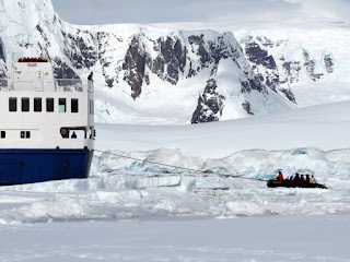
As the ship shuddered to a halt our expedition leader decided to give us a unique pack ice adventure. We took to the zodiac boats and spent several hours cruising among some of the most stunning icebergs and ice forms we saw in Antarctica. Along the way we encountered several basking crabeater seals, birds battling for fish and endless waves of penguins porpoising their way through gaps in the pack ice.


At one point our guide rode the zodiac up on to an ice flow and invited us to step “ashore”. For more than ten minutes we stood on the ice watching penguins dive into the surf while soaking up the ice-filled scene around us. I can now claim to have stood on an iceberg more than 65 degrees south. The photo posted here is my proof (that's me waving in the bright blue jacket)!

Shortly after this encounter our guide’s radio began crackling with a burst of transmissions. We soon heard that three other zodiacs had become trapped in the moving pack ice. After struggling to free themselves each boat eventually radioed for help from our cruise boat. The big ship then carefully made its way through the pack ice to free each trapped boat, with the exception of my own. It took our boat more than an hour to make its way through a channel that had become blocked by pack ice in the time we’d been on the water. 


Each guide later claimed it was the first time they’d ever been stuck in pack ice. I must admit I did wonder if the entire event had been planned for our entertainment. Regardless the experience was a sobering demonstration of how easy it was for the ships of early explorers to become trapped in pack ice, thus dooming their crews to a winter in Antarctica. I now have a far healthier respect for the danger these pioneers faced and the power of nature in the polar regions.

Read on to share the moment we finally set foot on the world's seventh continent.

Saturday, December 25, 2010

A white Christmas like no other

Weather-wise our first excursion on Christmas Day was probably the least pleasant of our entire cruise. We woke to heavy, sleeting rain. However, our wet weather gear proved more than adequate and so our time outdoors wasn’t particularly onerous. We made our way onto D'Hainaut Island, a small 1km wide rocky outcrop in the middle of Mikkelsen Harbour. This sheltered harbour is located on the southern shores of Trinty Island. 

During our trek across D'Hainaut Island we encountered seals basking in the snow, skuas loitering for eggs (or chicks), and thousands of nesting Gentoo penguins. It was here that we saw our first penguin eggs and witnessed the practice of penguins stealing stones from each other to build their nests.

We then returned to the boat for a hearty Christmas brunch. The ship then sailed south again to Cierva Cove where boarded our zodiacs once again for a leisurely cruise between icebergs carving off a nearby glacier. It was here that we also laid eyes on the Antarctic mainland for the first time. This sighting consisted of spectacular sheer rock cliffs rising into the clouds above. The weather also played its part as the sleet had been transformed into large fluffy snowflakes. I can honestly say that cruising between iridescent blue icebergs surrounded by perfect snowflakes has to be the ultimate White Christmas experience.

The wildlife was also out in force. We encountered a Weddell Seal basking on an ice flow. As we glided by he raised his head and stretched out a flipper as if offering us a leisurely wave. The guides then surprised us with an impromptu zodiac gathering offshore. The boats were latched together and cups of hot chocolate laced with rum were handed around for us to toast our Antarctic Christmas.

The remainder of the day was spent leisurely cruising south along the Gerlache Strait. This stunning waterway is framed to the west by islands of ice-capped, soaring granite peaks; to the east lies a chain of equally high, jagged peaks that run the length of the Antarctic peninsula. It was here that Garry finally fulfilled his dream of seeing Killer Whales in the wild. For almost 20 minutes we watched a pod of these beautiful creatures frolic less than 100 metres away and at one stage the pod briefly swam under our ship. We even saw a small Orca calf swimming alongside its mother.


Read on for more about our Antarctic adventures as the weather and scenery progressively improved.

Friday, December 24, 2010

Wildlife encounters galore

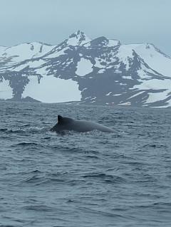
Within hours of boarding the Ocean Nova, our expedition leader had us boarding zodiacs for our first zodiac excursion. We spent more than an hour chasing a humpback whale that had been spotted feeding along the shore of Maxwell Bay. In the distance we could see thousands upon thousands of penguins nesting on the shore, including many lining low ridges above the beach. As we cruised in our zodiacs we witnessed time and time again penguins “porpoising” through the water. This is basically a technique they use to avoid danger. It involves leaping out of the water as the birds swim, making for a wonderful spectacle of nature.

After lunch we took to the boats again. We’d been given permission to visit the penguins colonies we’d seen earlier in the day. This excursion proved to be a real highlight of our cruise. We landed on small pebble beach and were immediately told to avoid the juvenile Elephant Seal lounging further along the shore. Our expedition guide took us slowly along the shore as penguins came and went in front of us. As we walked we spotted three separate species; Gentoo, Chinstrap and Adele.

 We eventually found ourselves at the base of a rocky outcrop where Gentoo and Chinstrap penguins were nesting. This was a magical moment. We spent more almost 30 minutes watching penguins feeding chicks, some barely a week old. We were told that penguins in the area had bred early this year and so we’d witnessed an unusual sight. Days later, further south we encountered nesting penguins all of which were still incubating their eggs.

I can also report that penguin colonies stink. It seems that thousands of nesting birds generate a lot of guano. It covers the rocks and shoreline in every direction; and simply stinks. As a result, every time we returned to the ship we scrubbed our boots in a disinfectant bath before returning to our cabin. The same procedure was conducted each time we left the vessel. This practice discourages the introduction of alien species into the Antarctic environment.

Shortly after the start of dinner we pulled up anchor and headed 130 kilometres south across the Bransfield Strait which separates the South Shetland Islands from the Antarctic peninsula. This was the only stretch of open sea we experienced on our entire cruise. Thank goodness. During the crossing we encountered 40 knot gales which had most of us feeling rather uncomfortable within hours.

I eventually retired to bed in the clothes I was wearing after my head began spinning. I dared not move again for fear of losing my dinner. Fortunately, the night passed without incident and we woke to calm waters in Mikkelsen Harbour, Trinity Island; located at the head of the ever so scenic Gerlache Strait. The crew later told us that our crossing of the Bransfield Strait would have been considered a relatively smooth Drake Passage crossing. I can safely say this insight immediately vindicated our decision to spend more flying to Antarctica.

The photos above give you a taste of the truly stark, breath-taking polar scene that greeted us when we woke on Christmas morning. Click here for more about our icy Christmas Day excursions as we cruised among icebergs more than 64 degrees south.