From Cusco, we caught the train to Machu Picchu. This was another stunning journey. We weaved our way through narrow valleys where towering mountain walls seemed to almost touch. Highlights included ubiquitous craft sellers offering their handmade goods through the carriage window at every station, plus a brief stop at Kilometre 104 where the Inca Trail’s most popular day trip begins. We saw several ambitious hikers get off the train here.


The 104 Kilometre access point is approximately 12 km from Machu Picchu. They say that, if you're fit enough, you can walk this section in a single day. Apparently, some people get off the train here, hike to the ruins, and spend two hours exploring before catching a train back to Cusco that evening. The more hardy trekkers start the classic trail at 82 Kilometres after disembarking in Ollantay Tambo. It then takes four days to walk to Machu Picchu.


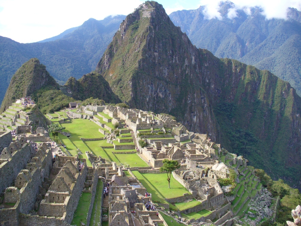
As for Machu Picchu, these Inca ruins were exactly as depicted in postcards and books. This is one tourist site that not only lived up to expectations but exceeded them. We enjoyed a picnic lunch overlooking the ruins on our first day, interrupted by a brief mist of rain, before walking the final section of the Inca trail.
A three kilometre uphill hike took us up to Inti Punku, the Sun Gate, which overlooks the entire valley. I loved the view. However, some of the narrower terraced sections were a little too nerve-wracking for Garry. The day had been largely overcast until we reached the gate. True to its name, the sun broke through, and in the distance, Machu Picchu glowed a wonderful vivid green.


The following morning we visited again at dawn. Clouds were swirling around the site as we arrived giving everything a completely different mood. I then bravely climbed the nearby peak of Huayna Picchu. The ascending trail was damp and near vertical in places. However, the view from the top was well worth the huffing and puffing to get there. The trail back down was a whole different story.


What the guidebooks don't tell you is that shortly after reaching the summit you return by descending two flights of ancient Inca stairs. Each is at least 100 metres in length, with a sheer drop of literally hundreds of metres to the valley floor. Of course, there are no handrails and some of the rock steps are less than 40 cm wide and 20cm deep. I literally clung to the side of the mountain and watched my life pass me by!

The first of these terrifying stairways can be seen in the photo above. This view, taken from the top of stairs doesn’t do it justice. The vertigo you experience is hard to describe and angle of descent is difficult to grasp.
For example, the little white dot that you can see at the bottom of the stairs is a large 40-litre rubbish bucket. Beyond the edge of each step is the valley floor, almost 800 metres below. The photo below, pulled from the web, shows the same stairway from another angle.


The first image above gives you a sense of the vertical drop, while the second reveals how narrow the stairs were in the most treacherous section (take a closer look at the right side of this image!). I've also included a third image taken from below to give you a better sense of the shear vertical drop involved. It really is that steep!


Of course it would be remiss of m not to acknowledge that the views on offer were equally jaw-dropping. The image above shows the superb aerial view of Machu Picchu I enjoyed while descending this final stairway. The misty cloud cover also conveniently hid the deadly drop more than once.


I'll finish this post with a few images that capture Machu Picchu's cultural highlights. This includes its intricate stonework, irrigation and drainage channels and the only surviving fully intact Intihuatana, a mysterious Incan device used for astronomical observations and ritual ceremonies.


For example, the little white dot that you can see at the bottom of the stairs is a large 40-litre rubbish bucket. Beyond the edge of each step is the valley floor, almost 800 metres below. The photo below, pulled from the web, shows the same stairway from another angle.

However, it was the next set of stairs that truly did my head in. To reach them visitors pass through an abandoned, roofless stone hut. It’s visible at the base of the stairs in the image above. The hut’s level ground and sturdy walls create a false sense of security, a sense that the worst of the descent is behind you.
Nothing could be further from the truth. As you exit the far end of the hut you’re confronted by a near vertical stairway, steeper and more terrifying than the last. Visitors must descend this to reach the main hiking trail below. Here’s a series of images that tell the story better than I can.
Nothing could be further from the truth. As you exit the far end of the hut you’re confronted by a near vertical stairway, steeper and more terrifying than the last. Visitors must descend this to reach the main hiking trail below. Here’s a series of images that tell the story better than I can.


Finally, in case you don’t believe me, above is a photo ripped from the web, that shows that final descent from another angle. Unlike the group in this image I didn’t have the comfort of others to inspire me. Instead, it was just me and a young woman I met part way down encouraging each other to keep going. Truth be told, she was just as mortified as I was by the narrow stone steps. We both swore, “Never again!”


Earlier in the day Garry had sensibly refused to even consider climbing with me. He spent a comfortable afternoon drinking beer at a local restaurant with others from our tour group. A wise man. Although I did notice an interesting flash flood escape route sign on the wall outside - perhaps he wasn't so risk-averse after all?

The Intihuatana stands in the middle of the Sacred Plaza, the highest elevation in Machu Picchu's central complex. It follows a tiered, pyramid-like setup, topped with a small rock needle carved from a single slab of rock. Through its high elevation, it is thought to connect the different levels of the Inca mythology (Hana pacha, Kay pacha, Ukhu pacha; Spiritual World, Now, Underworld) in one focal point.
This stone dais looks a bit like a sundial, which is actually not far from the truth. During the two equinoxes (21 March and 21 September) the sun stands directly above the Intihuatana – creating no shadow whatsoever. Its precise placement hints at the incredibly rich astronomical knowledge of the Inca.


After two days of exploring these iconic ruins, we caught a late afternoon train back to Cusco. We then spent a final relaxing day wandering the city with others from our tour group. From here, a smaller group flew onward to the Amazon.

One final comment. Words cannot describe the sheer beauty of Machu Picchu. We took literally hundreds of photographs during our two-day visit. It's been a challenge to select just a handful to illustrate this post. On reflection, we were incredibly lucky to visit in such good weather, enhanced by interludes of drifting rain and dramatic mist. I hope that the images I’ve chosen bring the majesty of this special place to life.


No comments:
Post a Comment