It’s retrospective post time again. In October 1990, I spent five days in Morocco while backpacking in Europe. At the time, I was travelling with Dean, a sheep farmer from Victoria. Visiting Morocco was a genuinely transformational experience. It was my first immersive contact with a Muslim culture, my first exposure to life as a racial minority, and my first encounter with true poverty.
Our Northern Africa excursion was an eleventh-hour itinerary change. While exploring Andalusia and Gibraltar, fellow travellers encouraged Dean and I carry on into Morocco. We decided to give it a go after arriving by train in Algeciras, a port city overlooking the Mediterranean, on Saturday, 6 October. We arrived mid-morning, and transferred to a local bus for La Linea de la Concepcion, a town on the border with Gibraltar. Here crossed the border and spent time exploring the Rock. I’ll share more about our time in Gibraltar in a separate post.
We slept overnight in Gibraltar, then crossed back into Spain the following morning and made our way to the port in Algeciras. On the advice of fellow backpackers, we repacked a couple of day packs with enough clothing and essentials to last a week, before storing our primary backpacks in coin lockers at the ferry terminal. I must confess that we blithely ignored signs warning that the lockers would be emptied after 48 hours if their contents weren’t collected.
It seems we weren’t the first itinerant travellers seeking to store luggage for extended periods at the port. However, other backpackers reassured Dean and me that the port authorities would simply move uncollected luggage to a nearby storage room. Although I must admit that some experiences shared by returning travellers were less reassuring.
For example, we met an English backpacker coming off the ferry who told us he’d been robbed in Morocco, driven to the port, given money for a ferry ticket and told never to return. As I recall, he’d met a group of young men one evening who’d offered him hashish and a good time. However, a good time soon morphed into a robbery and pseudo-kidnapping. Dean and I decided hashish wouldn’t be added to our bucket list of travel experiences.
The ferry to Tangier took less than two hours to cross the Strait. However, during that time, we also crossed an unanticipated cultural divide. I distinctly recall feeling uneasy on board. At first, I couldn’t work out why until the realisation struck home. Dean and I were an ethnic minority. Except for two English couples we ran into, we were the only Caucasians on board, and among the only English-speaking passengers. Everyone else was a dark-haired, tanned Arab, or appeared to be of that origin.
Until that moment, at the age of 25, I’d never found myself in a situation where I was an ethnic minority. For the first time in my life, I suddenly understood, in some small way, what it felt like to be part of a minority group. I’ll never forget the sense of vulnerability and the perceived loss of situational power I felt on that boat. It was one of those life-defining moments that only travel can deliver.
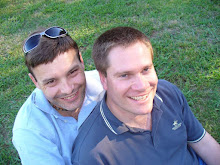
Dean and I understandably gravitated towards the English couples on board. We ended up drinking beer and swapping travel stories with Craig and Linda (on the left in the image above), and their friends Tony and Cath (on the right above). The two couples were friends from England travelling together in a campervan they’d driven through France and Spain. They were now headed to North Africa. They invited us to travel with them to Fez, their first destination. Free transport through Morocco was an opportunity simply too good to pass up.
Upon disembarking in Tangier, we drove south through the dry and dusty Moroccan landscape with our newfound English friends. It took us more than five hours to reach the ancient city of Fez, nestled in the northern foothills of the Atlas Mountains. We knew nothing of the city before our arrival. Our dog-eared travel guide didn’t have any chapters on North Africa. We were literally travelling “off the page” in the pre-Internet era.

Fez is a truly remarkable place. It’s been called the "Mecca of the West" and the "Athens of Africa". It is also considered the spiritual and cultural capital of Morocco. It has the world’s largest intact medieval city, with a pedestrian-only medina (old city) covering 2.2 square km.
For the next three nights, our group based itself at a campground on the edge of the modern city. One couple slept in the van, the other in a tent, while Dean and I slept in the open air under the stars. Much to our surprise, the entire campground was shaded by Australian Eucalyptus trees. Never in a million years could we have anticipated camping in Africa under the shade of Australian native trees.
The next two days were a blur of cultural and sensory overload. We’d all heard horror stories of tourists getting lost in the medina’s sprawling labyrinth of laneways and enclosed cul-de-sacs. To avoid the same fate, we all chipped in and hired a local guide to take us through the best of Fes. Our first day was spent exploring the modern city and Fes el-Jdid, its “new medina”. New, of course, is a relative term. Fes el-Jdid was founded in 1276. Our second day was spent in Fes el-Bali, the oldest and original ancient city, founded between 789 and 808.
We begged our guide not to take us to a selection of cliché tourist traps. We also made it clear that we didn’t want to spend our time visiting an endless stream of handicraft workshops. By and large, our guide delivered. We got to explore and see the best of Fes and its mind-blowing medina, visiting only one Persian rug showroom during the two days we spent with our guide.
The sights, sounds and smells of Fes are hard to describe. This was also my first encounter with truly non-European culture, making the contrast uniquely memorable. Until then, my travels had been limited to the USA, Canada, Australia and New Zealand, plus recent adventures in Western and Eastern Europe. For example, consider the three children shown in the image above. We encountered them carefully chiselling ceramic tiles into an array of mosaic shapes while touring the Medina.
Our guide had taken us into the back streets to learn how mosaics on the city’s monumental gates and buildings were made. In a tiny workshop, we were introduced to groups of children tracing mosaic shapes onto glazed ceramic tiles while others chiselled them into the finished shape. Our guide explained that these children worked for a living, helping their families earn enough to survive. The poverty we witnessed was a shock to say the least.
Perhaps the most mind-blowing sensory experience was the Chouwara Tannery. This ancient open-air complex was extraordinary. You could smell it long before you could see it. Here, animal skins are cured with quicklime, cow urine and pigeon poop by men pounding with their feet, then are dyed in a series of tiered, round vats of vivid yellow, red, green or blue.
In the words of one travel writer, “the process is medieval and will challenge both your olfactory nerves and attitude to voyeuristic tourism.” I couldn’t agree more. For example, in the foreground of the image above is a pungent pile of rotting hides. These were the rejects from earlier batches, casually discarded and simply left to decay. It’s hard to fathom that animal hides have been cured and prepared this manner, in this location, for almost a thousand years.
Other highlights included Bab Boujloud, a monumental gateway leading into the old city. Through its ornate Moorish horseshoe arch, you get your first spectacular glimpse of the medina inside. The locked entrance doors to the Dar al-Makhzen, the King of Morocco’s Royal Palace, in Fes el-Jdid were equally impressive (that’s us above standing in front of them).
One of our travelling couples decided to shop for a rug. As a result, Dean and I were entertained by locals wielding oodles of hot, sickly sweet mint tea while they shopped for the perfect rug. Once selected, your chosen rug was expertly folded and stuffed into a canvas shopping bag ready for dispatch. You could take it with you or have it delivered directly to your home.
The craftsmanship on display was impressive to say the least. It’d be another decade or so before I’d explore similar showrooms in India and the Middle East. However, nothing will ever compare to this first encounter with a non-European culture. The novelty of this incredibly exotic experience is neatly captured by the image above.
Likewise, Dean and I were fascinated by the local women dressed in their traditional burqas. Most also had their faces fully veiled. We'd never seen anything like it and wanted to capture this cultural experience in a photo. However, it quickly became clear these women didn’t want to be photographed. In the end, we resorted to a rather culturally insensitive solution. We took photos of each other in the medina’s laneways, timing the photo to include a passing woman. This post opens with one of these images.
We also visited the elegantly white-washed Jewish cemetery in the city’s old Jewish quarter. Once again, my naivety was made manifest. Until this moment, I’d never known that something as fundamental as burying the dead could differ between cultures. Likewise, the cemetery tells a troubling story of European persecution. We learned that large Jewish communities developed in Morocco and elsewhere in Northern Africa after the Jews were expelled by royal decree from Spain in 1492 and Portugal in 1497.
By the mid-16th century, the Jewish quarter in Fes had an estimated population of 4000, and by the end of the 19th century, it had some 15 active synagogues. However, these days the cemetery is little more than a memorial to a community that has long since vanished. By 1997, there were reportedly only 150 Jews living in all of Fez, and no functioning synagogues remained. Travel really does broaden the mind.
A few kilometres further on, by the ruins of the Merenid Tombs, we stopped to enjoy a stunning view of the medina. These picturesque 14th-century mausoleums were built by the Merenid dynasty that once ruled Morocco. Below us, a carpet of goat skins was scattered across the hillside, drying in the sun. In the distance, the chaos of the media unfolded across the valley.
It was easy to see why tourists were warned not to tackle its sprawling expanse without a local guide. Of course, these days, the magic of GPS and Google Maps has transformed the experience as Garry and I aptly demonstrated while tackling the laneways of Marrakesh
earlier this year.
On 10 October, we left Fez and began retracing our steps back towards Spain. We farewelled our new English friends and headed for the nearby city of Meknes. Follow
this link to learn more about our brief stop in this equally ancient city.
Weeks later, we caught up for a drink with Tony and Cath in London. They told us that the campground subsequently charged them an additional “tent fee” because Dean and I had strung up a plastic sheet to shade our sleeping bags. At the time, we’d paid for an entry-level “open-air” camping fee and slept under the stars. None of us thought that a sheet draped over a string would be deemed a tent.


_DSCF5775.jpg)