
I can personally attest to their natural beauty, having visited them while backpacking in Europe in 1990. My travel buddy, Dean Keiller, and I spent five days exploring the Lofoten Islands by land and by sea. Our island adventure began on 22 August with an early morning train from Trondheim to Bodø. For the next ten hours, we wound our way north, covering a distance of 729 kilometres.
We then caught an early evening bus in Bodo and travelled another 300km to Narvik, arriving shortly after midnight. Our journey north included an eight-kilometre ferry crossing over the scenic Tysfjorden. Despite the late hour, we completed the half-hour crossing in fading daylight, thanks to the lingering twilight of an Arctic Summer. Passengers were also allowed to disembark and soak in the view from the open deck. I still recall marvelling at the shadowy vista unfolding as we sailed.
I also vividly recall getting off the bus in Narvik, along with a small contingent of fellow backpackers, and standing there in the dark, wondering what we’d do for accommodation. The hostel was closed for the night (assuming we could find it without a map), and none of us knew the municipal campground’s location. After some debate, the group decided to head into town and find a discreet place to camp for the night.

We eventually stumbled across an elevated bandstand shrouded by a concrete shell in Parkhalltaket, a nearby public park. Here we rolled out our travel mats and sleeping bags around 2:00am and spent the night sleeping on the stage. Dean was enthralled by the twilight sky at such a late hour. We’d arrived in Narvik just weeks after the midnight sun started setting again. As a result, we experienced less than two hours of dusky darkness before the horizon slowly lightened once again.
The image above was pulled from Google Maps. It's remarkable to see that the bandstand is still there, more than 35 years later. However, the stainless steel Trinigon 3 National Freedom Monument for peace and freedom is a new addition. It was erected in 1995 to commemorate the 50th anniversary of the Allies' liberation of Narvik during the final months of World War II.
The following morning, Dean and I caught a local bus to Harstad, a coastal town about 100km further north. At the time, Harstad was considered the gateway to the Lofoten Islands. Once a week, the Hurtigruten, a postal ferry, docked here before sailing to Svolvær, the island chain’s de facto commercial hub, and onward to Bodo.
We booked ourselves into the local camping ground, a relatively simple affair located on a small promontory about 5km from the centre of town. Decades later, I still marvel at the fact that we walked into town and back without a moment’s hesitation. Although the following day, I decided to hang out at the campground while Dean ventured back into town. He returned late afternoon with fish fresh off the boat, which we cooked for lunch and again for dinner.

Harstad was the farthest north we ventured when backpacking in Europe. I still recall our excitement as our train crossed the Arctic Circle south of Bodo. The milestone was made all the more memorable by a herd of reindeer who broke from the trees shortly after and ran along the tracks for more than a hundred metres.
We had high hopes for our postal ferry excursion. However, Trollfjord was the only truly noteworthy fjord we ultimately saw in Norway. The northern end of Tengelfjord was also rather picturesque. However, it's more of a narrow sea strait rather than a fjord. In places, the strait was less than 200 metres wide, with dramatic slopes rising from the water on either side. I hope to return one day and drive the fjord-filled E39 coastal highway.

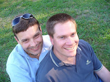
The following morning, we joined backpackers from our hostel on a hike up the Steinetind, a 509-metre peak, and neighbouring Mannfallet, a mere 308 metres high. The views along the ridge line trail were simply breathtaking. The photo that opens this post was taken near the highest point on our trek, and if you look carefully at the photo below, you'll find me perched on a grassy knoll. A diary entry I made that evening noted that we picked blackberries growing wild across the mountains and enjoyed locally smoked fish for dinner.

Later that evening, we caught an overnight ferry back to Bodo. We slept on the deck along with other backpackers. Dean and I were quickly learning that there was safety in numbers wherever we chose to sleep in the open. According to my travel diary, we eventually docked in Bodo shortly after 4:30am.
In Bodo, we met a retired air force serviceman in a bustling cafe. He’d been stationed in town during the Second World War. The old man happily regaled us with wartime stories about the bombing of Bodo before recommending a visit to the local air force base alongside the airport.
The base is home to NATO’s Quick Reaction Alert Aircraft. F-16 fighter jets of 132 Luftving are based here, ready to respond at a moment's notice to unidentified aircraft in or approaching NATO airspace. Dean and I were lucky enough to see military jets taking off and landing from the edge of the airfield at regular intervals. The roar of their jet engines and their spectacular drone-chute-assisted landings kept us enthralled for more than an hour.
Later that day, we ventured out to Saltstraumen, an impressive maelstrom, about 45 minutes by bus from the centre of town. Four times a day, a huge volume of water forces its way through a 150-metre narrow strait, generating chains of powerful whirlpools in its wake. We watched them in action from a road bridge passing overhead and from rock slabs along the shoreline. Dean decided this was the perfect opportunity to enjoy his first—and only —swim above the Arctic Circle. I politely declined the offer to join him in the frigid Arctic waters.


No comments:
Post a Comment