Saturday, July 06, 2019

Kati Thanda


I’ve always wanted to see Lake Eyre in flood.  It’s renown for two geological records; the dry lake bed is the lowest natural point in Australia (approximately 15 m below sea level) and on the rare occasions when it contains water, it’s the nation’s largest lake (covering 9,500 km2). 

For much of its time, the lake is a dry and dusty salt pan.  It fills completely only a few times each century; with less dramatic flood events happening every three to ten years. However, each time it fills, the water rapidly evaporates and is all but gone by the end of the following summer. 

Earlier this year a series of cyclones in the tropical north sent floodwaters flowing through the lake’s catchment resulting two separate flood events that have filled the lake to its greatest depth in almost a decade.  As luck would have our road trip through the Red Centre coincided as the second flood was reaching its peak.

I decided to shout Garry an early birthday present and booked us on a half-day flight.  The tour departs from Coober Pedy airport shortly after 8am. On board were the two of us, a couple from Melbourne and our pilot.  Our flight took us across the desert, passing over the Oodnadatta Track, the Outback town of William Creek and on to the lake itself.


The lake was magnificent!  Our tour took us over the northern limb of Kati Thanda–Lake Eyre as its officially known, then across the mouth of the Waburton River and into the surrounding channel country.  The floodwaters here had breached the river bank filling the area with sun-speckled, water-filled pans and streams.

We then headed south along the lake’s Waburton Groove, a deep channel in the middle of the lake that feeds water towards its southern-most, and deepest points, called Belt Bay and the Madigan Gulf.  The view was genuinely breath-taking.  Water stretches out in gentle fans across sodden mudflats, surrounds two of the lake’s temporary islands and slowly transforms itself into a classic aqua expanse at its deepest point.

Our pilot even took us on a brief detour over the top of one island where we could see the occasional tree clinging to life on the desolate rocky ground.  We were also lucky enough to see a large flock of pelicans in flight.


From the lake, we flew on to William Creek, where we landed for an hour on the ground.  The tour fed us morning tea at the local hotel (said to be one of Australia’s remotest pubs) and then left us to explore the township and its “town square”.  The town has a population of 10 and contains just a handful of buildings; many of which support the local airstrip and nearby Anne Creek Cattle Station.


It’s also a popular fuel stop on the Oodnadatta Track, sitting halfway between the track’s northern entry point at Marla and the Oodnadatta township further south. In the brief time we were on the ground, a stream of four-wheel-drive vehicles constantly drove in and out of town.  However, the highlight was the arrival of an enormous triple-trailer cattle truck that heralded its approach with a massive billowing dust cloud.


The final leg of our flight tour took over the recently “discovered” Painted Hills.  These hills rise from the Outback in a series of spectacular banded domes and outcrops.  Our pilot landed on a remote gravel strip and took us for a trek through the foothills of one particularly impressive formation. The colours of the rock were simply awe-inspiring.  Bands of ochre, yellow, red, purple, orange and grey (and myriads of hues in between) encircle the hills in candy stripes.


Our tour then finished with a flight over the Stuart Highway and Coober Pedy township.  As our aircraft slowly turned and lined up for final approach we were presented with a final dramatic sweep over the region’s unique landscape filled with pile after pile of opal mining rubble.


Sunday, June 30, 2019

Coober Pedy


Without a doubt, Coober Pedy is one of Australia’s iconic places.  The name always evokes and embodies some of the nation’s more compelling mythology about the grit and hardship of frontier living.  The township sits nestled on the edge of an erosional scarp of the Stuart Ranges. Wikipedia aptly describes the town as follows; "very little plant life exists in town due to the region's low rainfall, high cost of water, the sandstone and lack of topsoil".

Coober Pedy isn’t for the faint-hearted.  It owes its entire existence to the discovery of Opals by Wille Hutchison on 1 February 1915.  Today, the area surrounding town supplies a majority of the world’s gem-grade Opals. 


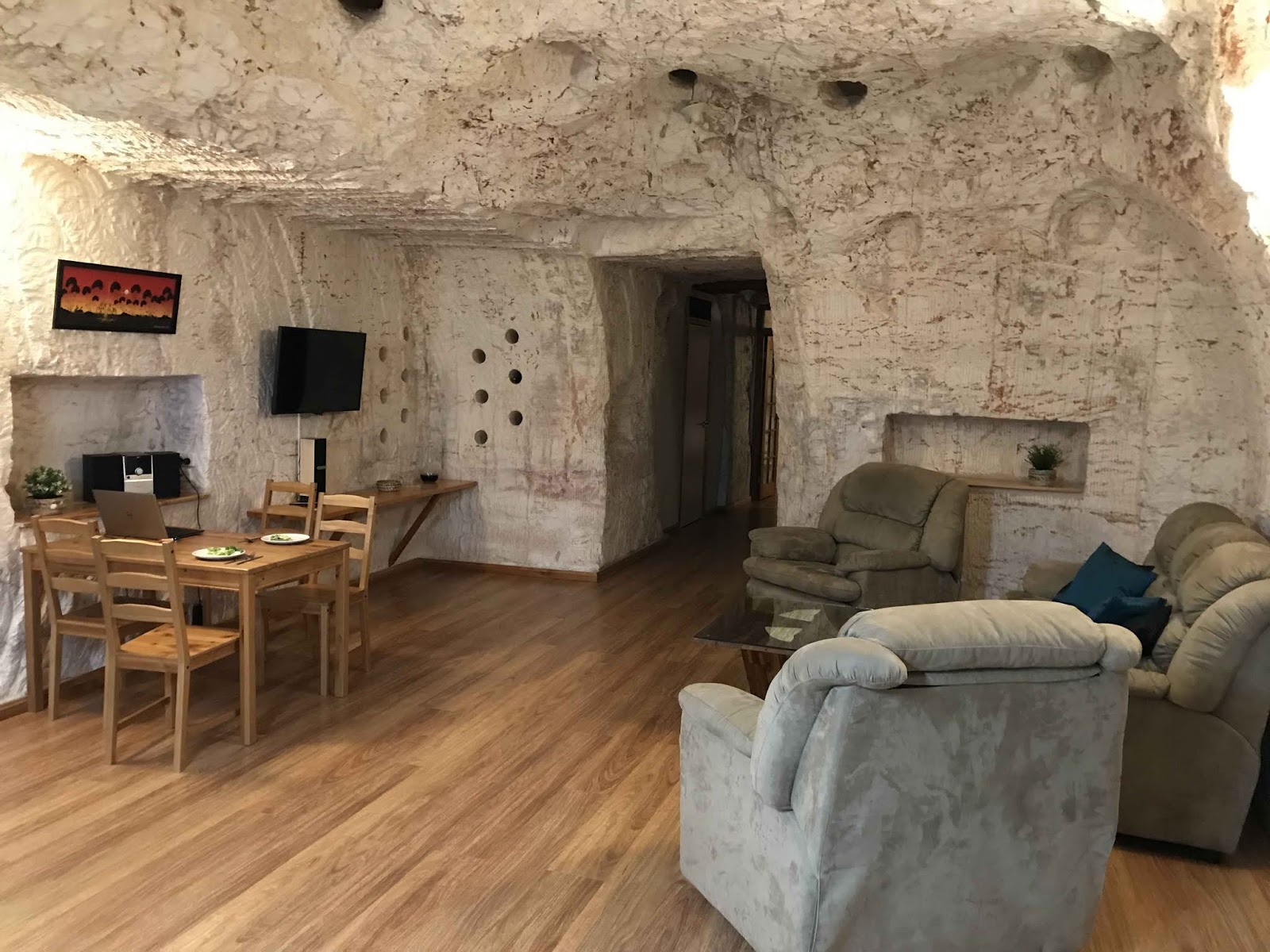
This barren outpost boasts an annual average high of 27.5 °C. Summer temperatures range from 35 °C and upwards in the shade, with occasional dust storms. The annual rainfall is amongst the lowest in Australia, at around 130 millimetres (5.1 in).  The harsh summer temperatures mean that many residents prefer to live in caves bored into the hillsides (commonly referred to as dugouts).


A standard three-bedroom cave home with lounge, kitchen, and bathroom can be excavated out of the town’s hillside rock for a similar price to building a house on the surface. However, dugouts remain at a constant temperature, while surface buildings need constant air-conditioning.  Garry and I stopped here for two days, basing ourselves at the truly immaculate Dugout B&B on the edge of town.


The dugout was one of those rare finds where the stunning online images more than match the reality you find upon arrival. We hired the largest apartment which sat on a dusty plateau overlooking the surrounding desert.  Each night we sat outside and watched the full moon rising over the Outback while warming ourselves in front of campfire blazing in the half-cylinder of a 44-gallon drum.

We spent an afternoon exploring Coober Pedy after a morning flying over Lake Eyre in flood (more about that adventure in a separate post!).  Highlights included a tour of an Opal mine, a local underground church and a leisurely stop at the town’s panoramic Big Winch Lookout.


The Umoona Opal Mine & Museum in the centre of town was a genuine highlight.  We joined a guided tour that took us through a local dugout home and then down into the depths of a former Opal mine.  The underground museum included a range of exhibits about opal mining, desert fauna and indigenous history.  We also enjoyed a fascinating 20-minute documentary about life in Coober Pedy in an underground cinema.


Australia’s opal capital also delivered a few unexpected highlights. Late one afternoon while standing on the edge of our dugout’s plateau we witnessed an empty Double B road train make its way along the unpaved Williams Creek Road. As it lumbered towards the horizon it threw up an enormous cloud of dust that swirled and bellowed in the setting sun’s golden rays. We saw a similar dust cloud tracing its way through the desert the following day while visiting Williams Creek.

However the most unexpected highlight of our time in Coober Pedy was the appearance of a wallaby and joey outside our apartment shortly after dusk on our final night in town.  The pair sat watching us for some time before eventually bounding away after curiosity got the better of us and we attempted to approach them.

Woomera


As a self-confessed space geek, I’ve always wanted to visit Woomera.  It’s the closest thing we have to the Florida Space Coast in Australia.  Woomera township was the heartland of British and Australian rocket science for the better part of three decades.  It was here that scientists tested rockets and launched satellites into orbit, including Australia’s first and only satellite launched from Australian territory.

Construction of Woomera Village began in mid-1947 to cater for thousands of people arriving as part of the Anglo-Australian Project. During its heyday (1949–71), the village population reached around 7,000 as people lived and worked here.  Woomera Village initially operated as a "closed town" between 1947 and 1982, but today welcomes visits by the general public.


 The township itself is rather unique.  As one commentator rightly described it, the town’s surprisingly well-developed infrastructure and orderly layout could easily be mistaken for a quintessential Canberra suburb.  The roads are paved, shaded by trees and lined with well-maintained kerbs and sidewalks.  It bears little resemblance to the more ramshackle townscape you typically encounter in the Outback.

The town even boasts an indoor bowling alley, cinema, public pool and several well-maintained social clubs including an RSL Club despite being home to less than 300 people.  However, without a doubt, the real highlights for me were its rocket parks and museums.  


In the centre of town reside two rocket parks; with duelling rockets competing for attention on the opposing corners of a quiet intersection.  Each is populated by an impressive series of rockets and military hardware.  Highlights include a vertically mounted Blue Steel rocket, a Canberra bomber and the battered remains of a Redstone rocket used to launch Australia's first satellite.

The Woomera Heritage Centre, located a few hundred metres away, was a real surprise.  Its incredibly well-presented interactive exhibits outline the history of the township, its once-secret military endeavours and hardship locals faced living on the edge of the Outback.  Garry and I spent more than three hours exploring the town and learning of its extraordinary history.

Woomera had one final highlight for us as we headed out of town for a four-hour drive to Coober Pedy.  As we drove out of town we encountered an Emu running down the highway. It dashed along the highway for 50 metres or so before finally veering off into the tussock.  It was ultimately the only sighting of an Emu in the wild during our entire vacation.

However, the day's greatest highlight was a leisurely stop at Lake Hart. This stunning lake is located about 47km north of Woomera.  It's here that the modern Ghan railway also winds its way along the lakefront making for some spectacular scenery.

Go North Young Man!


2019 is turning into a “stay close to home” year for our vacation plans.  So far this year we’ve spent time in Far North Queensland, NSW South Coast and more recently, spent 10 days driving through the Red Centre.  We’ll then finish the year with a Christmas vacation in Tasmania.

Our drive through the Red Centre covered new ground for Garry and I, as well as revisiting some old haunts we’d not seen for several decades.  Our adventure kicked off in Adelaide.  We collected an Apollo Motorhome mid-afternoon, stopped to provision it and then drove north to spend our first night in Port Augusta.


We decided to hire a camper van after Garry’s research revealed that it would cost less to do so than hiring a regular car.  Everyone we looked at charged a one-way rental fee that dramatically inflated this cost; up to $600 per hire.  However, for an unknown reason, a motorhome didn’t incur the same penalty.  We ultimately decided this presented a superb opportunity to experiment with the concept of becoming “grey nomads” in a few years time. 

We hired a deluxe vehicle with separate sleeping zones, permanent café style dining zone and a bathroom fitted out with a toilet and shower.  However, upon collection, we quickly discovered that deluxe referred more to its size and scale than the quality of its interior or the basic accessories included. A hard-won lesson indeed.

We ended up spending time at K-Mart buying basic luxuries such as a coffee plunger, high ball drinking glasses, serving platters, an electric kettle and serving tongs. Coles also had its free Tupperware container promotion running at the same time so we cashed in our reward points to secure some additional storage containers. 

Our extended shopping trip meant that half of our journey north was completed in darkness.  It was a shame as we’d hoped see the full extent of the famous Flinders Ranges as we drove.  However, all was not lost, as the following morning we took time out to drive through the ranges from Port Augusta to the picturesque country town of Quorn.


Quorn was a real treat.  The town has gone to great lengths to preserve many of its colonial buildings including its railway station.  The town was once a stop on the Old Ghan Railway to Alice Springs.  The original railway roughly paralleled the Oodnadatta Track.  This route traversed several dry lake beds that occasionally flooded and closed the line for weeks at a time.  In 1980 the railway was diverted on to a new line that ran 200km to the west of its original location.


From Quorn, we made our way back to Port Augusta where we spent the afternoon exploring a few of its popular sights.  This includes the Water Town, an unusual lookout built into the water tank of a preserved water tower, and an extended visit to the Australian Arid Lands Botanic Garden.  The garden overlooks the Flinders River and includes the spectacular Matthew Flinders Red Cliff Lookout.  The view of the Flinders Ranges was spectacular; as were the grounds of the garden’s themselves.


We finished the day with a two-hour drive to Woomera, arriving in time to enjoy a stunning sunset over the increasingly arid outback. Here’s more on our time in Woomera, a town that was once part of a highly restricted Defence zone.